November 20, 2017 © Thomas J. Kollenborn. All Rights Reserved.
Many of you have read articles I have written about tragedies in Superstition Wilderness Area over the years. Probably the worst tragedy was the three Utah prospectors that died in the summer of 2010. They were attracted to the mountain by stories of gold bullion buried near Yellow Peak. Their ignorance of conditions in these mountains during the summer months led to their deaths.
I can excuse somebody for going into the mountains under these conditions, believing they would return with sacks of bullion gold. Now I would like to tell you another story of incident that could have led to the same tragic end. Ironically, I was involved in this search.
Working on the Quarter U Ranch in the late fifties certainly familiarized me with the summer conditions in this mountain. When we had range work to do in the summer months we were horseback by 4:00 a.m. and would return to the ranch before noon, knowing how bad the heat could get in the afternoon. It is not any fun riding back to the ranch after a morning of hard work in the desert sun during the month of June or July. Cowboys, in general, loved the raining season on the lower desert and always looked forward to it.
Back in the late 1970s I was ask to help on a pack trip into the Superstition Wilderness Area on June 10. This particular year, the temperatures were ranging between 95° and 110°F for twenty-four hours a day. I knew the idea was a bit insane, however I was still young and in love with the history of these mountains and its people. It was summer time and I had plenty of time.
I got three horses from “Arkie” Johnston and packed this Dutch Hunter named Ernest into the mountains. He wanted to stay at least four days. I told him we would have stay where there was water. During the heat of summer this didn’t allow very many options. We could stay at, or near, Hackberry Springs, Second Water, Bluff Springs, or Charlebois. Ernest was interested in a spot on Peter’s Mesa. I couldn’t believe he wanted to go in this time of the year. He explained to me nobody would be out there in this heat and his knowledge would be better protected of golden treasure in a cave. We left First Water at 4:00 a.m. and it was still a little warm. It hadn’t cooled off much that night. We arrived at Charlebois Spring about 8:00 a.m. and set up camp. There was plenty of water for the horses, but sometimes difficult to water them. Ernest got his pack ready and strapped on his revolver. He started up the trail to the top of Peter Mesa. I stayed in camp with the horses. It was a hot, miserable day at Charlebois because of the gnats and bugs. I am sure the temperature got up to 110°F. At sundown there was no sign of Ernest. I soon became worried; after all, he was in his early sixties. Soon my concern was replaced with anguish.
Sometime after dark I heard a call for “help” coming from the trail to the top of Peter’s Mesa. I grabbed a shoulder canteen and a flashlight and started up the trail to Peter’s Mesa. I knew I would find Ernest somewhere along the trail. The climb up the trail caused me to perspire heavily. About a mile up the trail I found Ernest lying beside the trail. It looked like he might have broken his ankle or something. He was in severe pain. A simple pack trip was becoming an emergency for me. I told Ernest I was going back to get a couple of horses and it would be a couple of hours before I would be back. He kept trying to tell me about finding the cave full of gold bars. The truth was I didn’t care. We had an emergency at hand. I scrambled back down the trail to Charlebois Spring and picked up two saddle horses. I rode back up to the site where Ernest was lying. His leg really looked bad just above the ankle. At this point we couldn’t get his boot back on. I loaded him on the horse and put his injured foot in the stirrup. We then started the downhill ride back to Charlebois Spring. I told him I would have to ride out and get ahold of the Sheriff’s Office so we could get a helicopter in to take him out. Ernest said he was going to ride out. No helicopter for him. We made it back to camp. Closer examination of his foot revealed it was not broken, or at least not a compound fracture of any kind.
About 3:30 a.m. I corraled the horses and began to pack up camp. We were on the trail by sunup. Our ride out to First Water was basically uneventful other than Ernest talking about finding the “Cave full of gold bars.” I had several letters from Ernest in my files, but I never heard from him again. Many years later a relative of Ernest contacted me. He wanted to know if Ernest found anything in the mountains worthwhile. He seriously injured his foot. I told them I did not see anything worthwhile that he found, but he sure suffered gold fever and summer hell.
Monday, November 27, 2017
Monday, November 20, 2017
Edwin's War
November 13, 2017 © Thomas J. Kollenborn. All Rights Reserved.
 |
| Edwin flew 33 missions over Germany during World War II as a waist gunner on a B-24 Liberator bomber. Known to many aviators as the “flying coffin.” He flew out of an Army Air Corps base in Italy. The “Redtails” protected many of their flights over Germany. |
Monday, November 13, 2017
Arizona's Apache Trail
November 6, 2017 © Thomas J. Kollenborn. All Rights Reserved.
There is nothing more Arizona than the story of the Apache Trail and the challenges to build it between 1903-1905. This roadway was at the center of one of the first major efforts to promote Arizona and its beautiful climate by the Southern Pacific Railroad between 1915-1927. There are many stories about Arizona, however Arizona history would be incomplete without this story.
The Apache Trail can certainly be classified as one of the most adventurous and scenic routes in the American Southwest. Since 1906 tourists have traveled this unique mountain road and marveled at some of the most spectacular scenery in our state. The Apache Trail originally began in Phoenix and terminated at Roosevelt Dam. The most significant portion of roadway began at the Mesa railhead and terminated at Roosevelt Dam site on the Salt River some sixty-two miles away.
The approximate route of the Apache Trail has served humanity for more than a millennium. The Salado used the trail to penetrate the Salt River Valley around 900 A.D. Other Native American groups continued to use the trail as a migratory route between their winter homes on the desert lowlands and their summer homes in the mountains along the Mogollon Rim.
The Apaches and Yavapais used the trail for their predatory raids against the Pimas along the Salt and Gila Rivers south and west of Superstition Mountain. The Apaches and Yavapais continued their raids after the arrival of the Anglo-Americans in the early 1850s. Finally in 1864, Camp McDowell was established along the Verde River some four miles north of the Salt River. The Pimas became willing allies of the blue-shirted soldiers who manned Fort McDowell. This footpath (trail) along the Salt River through the mountains to Tonto Basin was called both the Tonto Trail and the Yavapai Trail on different occasions. The Army quelled the predatory ways Apaches-Yavapais in this region by 1868. There were other military campaigns fought against renegade Apaches from 1871 until Geronimo’s surrender in 1886 at Skeleton Canyon in Southern Arizona.
A young man navigated the Salt River near the present site of Roosevelt Dam to Phoenix in a cataract boat during the early part of the 1880s. He reported numerous ideal dam sites along the river’s course. The Maricopa County Board of Supervisors ordered a feasibility study done on the Salt River for possible water storage and flood control dam sites shortly thereafter. William “Billy” Breakenridge, James H. McClintock, and John H. Norton conducted a feasibility study for the county board of supervisors. Breakenridge also explored the route for a possible wagon road at the time of this study. Billy Breakenridge was a well-known Tombstone lawman during the 1880s. James McClintock became Arizona’s first official historian.
Breakenridge’s report was highly favored for the construction of a dam just downstream from the confluence of Tonto Creek and the Salt River. The Congress of the United States authorized the construction of a dam and the project was funded in March of 1903. The task of supervising the building of this dam was given to the newly formed U.S. Bureau of Reclamation Service under the United States Department of Interior. This was one of the first major building projects in America shortly after the beginning of the 20th Century.
Immediately after funds were approved by Congress the communities of the Salt River Valley realized no money was appropriated for the construction of a haul road from Phoenix to the dam site. The valley communities wanted to participate in this economic boom. They wanted a greater involvement in the market developed by the construction of Roosevelt Dam. The communities immediately worked on a bonding plan to raise enough money to fund the construction of the Mesa-Roosevelt Road.
Actual construction of the Tonto Wagon Road, as it was known in the beginning, began on August 29, 1903, with two hundred Apache laborers working just below the dam site on the Salt River. Another work camp was established on November 11, 1903, at Government Well, some twenty-five miles from Mesa, employing some 200 Pima laborers. The Tonto Wagon Road was completed on September 3, 1905, at a cost of $551,000. The road was sixty-two miles in distance, running from the Tonto Dam site to the Mesa railhead. It was reported that more than a million and half pounds of freight moved over the road in its first month of operation. By 1912, the year of statehood, Roosevelt Dam was completed and supplied water and hydroelectric power to the Salt River Valley and the mines at Globe.
The first Concord stage made a run over the Mesa-Roosevelt Road on June 10, 1905. The first automobile that traveled over the road from Mesa to Government Wells was on August 23, 1905. This Knox Automobile was known as the “Red Terror.” The first so-called tourist group to travel over the Mesa-Roosevelt Road was on October 10, 1905. The first major accident to occur on the Mesa-Roosevelt Road occurred between Mormon Flat and Fish Creek Hill with a stagecoach. The accident occurred on November 23, 1905. The curves, steep grades, and narrowness of the Mesa-Roosevelt road challenged the skills of early teamster and drivers. Even today, as we drive the Apache Trail, the road still challenges our skills as drivers.
The Mesa-Roosevelt Road was highly regulated during the construction of Roosevelt Dam (1906-1911), however, when the construction was over, the road became a favorite tourist attraction. The road was known as the Mesa-Roosevelt Road and Tonto Wagon Road during the period between 1903-1915. Sometimes the media called the road the Roosevelt Road. Shortly after 1915 the road became known as the Apache Trail. Historians appear to agree in general as to the origin of the name “Apache Trail.” They believe the term was coined by an enterprising young entrepreneur who worked as a railroad agent for the Southern Pacific. The man’s name was E.E. Watson. Watson was trying to promote the Southern Pacific’s “Sunset Limited” as it made its way through Arizona. The Southern Pacific offered a side trip for its transcontinental passengers over the Apache Trail if they were interested. Southern Pacific had the franchise on the Apache Trail as a special side trip for their passengers. The Southern Pacific Railroad promoted the Apache Trail widely in advertisements all over America and even in Western Europe from 1915 through 1929.
The Apache Trail (State Route 88) was officially dedicated as Arizona’s first historic highway on February 25, 1987, at Lost Dutchman State Park along the Apache Trail. Tourists have been traveling the Apache Trail since 1906. They have been enjoying one of the most beautiful desert highways in America. The Apache Trail is a roadway to adventure, beauty and history. President Theodore Roosevelt was given credit for the following words about the Apache Trail.
Recently the State of Arizona has done a lot of construction on the Apache Trail. These repairs were to recent storm damage along the “Trail” from last summer. The surface of the road is so rough between Apache Junction and end of the pavement six miles east of Tortilla Flat the road is going to be resurfaced. You should remember this road is not the responsibility of the state, county, or government. Actually the road is property of the Salt River Project originally, but its care and maintenance has shifted over to the ADOT. Legally who liability is the road in case of lawsuits as the result of accidents? I chaired the Historic Highway Committee in 1986-1987. We never found a responsible party for the Apache Trail. The State of Arizona did want to designate the highway “Arizona’s First Historical Highway.” Today, is debatable as to whether U.S. Route 66 or the Apache Trail was Arizona’s first historic highway.
 |
| Apache Trail on the Fish Creek Hill descent. |
The Apache Trail can certainly be classified as one of the most adventurous and scenic routes in the American Southwest. Since 1906 tourists have traveled this unique mountain road and marveled at some of the most spectacular scenery in our state. The Apache Trail originally began in Phoenix and terminated at Roosevelt Dam. The most significant portion of roadway began at the Mesa railhead and terminated at Roosevelt Dam site on the Salt River some sixty-two miles away.
The approximate route of the Apache Trail has served humanity for more than a millennium. The Salado used the trail to penetrate the Salt River Valley around 900 A.D. Other Native American groups continued to use the trail as a migratory route between their winter homes on the desert lowlands and their summer homes in the mountains along the Mogollon Rim.
The Apaches and Yavapais used the trail for their predatory raids against the Pimas along the Salt and Gila Rivers south and west of Superstition Mountain. The Apaches and Yavapais continued their raids after the arrival of the Anglo-Americans in the early 1850s. Finally in 1864, Camp McDowell was established along the Verde River some four miles north of the Salt River. The Pimas became willing allies of the blue-shirted soldiers who manned Fort McDowell. This footpath (trail) along the Salt River through the mountains to Tonto Basin was called both the Tonto Trail and the Yavapai Trail on different occasions. The Army quelled the predatory ways Apaches-Yavapais in this region by 1868. There were other military campaigns fought against renegade Apaches from 1871 until Geronimo’s surrender in 1886 at Skeleton Canyon in Southern Arizona.
A young man navigated the Salt River near the present site of Roosevelt Dam to Phoenix in a cataract boat during the early part of the 1880s. He reported numerous ideal dam sites along the river’s course. The Maricopa County Board of Supervisors ordered a feasibility study done on the Salt River for possible water storage and flood control dam sites shortly thereafter. William “Billy” Breakenridge, James H. McClintock, and John H. Norton conducted a feasibility study for the county board of supervisors. Breakenridge also explored the route for a possible wagon road at the time of this study. Billy Breakenridge was a well-known Tombstone lawman during the 1880s. James McClintock became Arizona’s first official historian.
Breakenridge’s report was highly favored for the construction of a dam just downstream from the confluence of Tonto Creek and the Salt River. The Congress of the United States authorized the construction of a dam and the project was funded in March of 1903. The task of supervising the building of this dam was given to the newly formed U.S. Bureau of Reclamation Service under the United States Department of Interior. This was one of the first major building projects in America shortly after the beginning of the 20th Century.
Immediately after funds were approved by Congress the communities of the Salt River Valley realized no money was appropriated for the construction of a haul road from Phoenix to the dam site. The valley communities wanted to participate in this economic boom. They wanted a greater involvement in the market developed by the construction of Roosevelt Dam. The communities immediately worked on a bonding plan to raise enough money to fund the construction of the Mesa-Roosevelt Road.
Actual construction of the Tonto Wagon Road, as it was known in the beginning, began on August 29, 1903, with two hundred Apache laborers working just below the dam site on the Salt River. Another work camp was established on November 11, 1903, at Government Well, some twenty-five miles from Mesa, employing some 200 Pima laborers. The Tonto Wagon Road was completed on September 3, 1905, at a cost of $551,000. The road was sixty-two miles in distance, running from the Tonto Dam site to the Mesa railhead. It was reported that more than a million and half pounds of freight moved over the road in its first month of operation. By 1912, the year of statehood, Roosevelt Dam was completed and supplied water and hydroelectric power to the Salt River Valley and the mines at Globe.
The first Concord stage made a run over the Mesa-Roosevelt Road on June 10, 1905. The first automobile that traveled over the road from Mesa to Government Wells was on August 23, 1905. This Knox Automobile was known as the “Red Terror.” The first so-called tourist group to travel over the Mesa-Roosevelt Road was on October 10, 1905. The first major accident to occur on the Mesa-Roosevelt Road occurred between Mormon Flat and Fish Creek Hill with a stagecoach. The accident occurred on November 23, 1905. The curves, steep grades, and narrowness of the Mesa-Roosevelt road challenged the skills of early teamster and drivers. Even today, as we drive the Apache Trail, the road still challenges our skills as drivers.
The Mesa-Roosevelt Road was highly regulated during the construction of Roosevelt Dam (1906-1911), however, when the construction was over, the road became a favorite tourist attraction. The road was known as the Mesa-Roosevelt Road and Tonto Wagon Road during the period between 1903-1915. Sometimes the media called the road the Roosevelt Road. Shortly after 1915 the road became known as the Apache Trail. Historians appear to agree in general as to the origin of the name “Apache Trail.” They believe the term was coined by an enterprising young entrepreneur who worked as a railroad agent for the Southern Pacific. The man’s name was E.E. Watson. Watson was trying to promote the Southern Pacific’s “Sunset Limited” as it made its way through Arizona. The Southern Pacific offered a side trip for its transcontinental passengers over the Apache Trail if they were interested. Southern Pacific had the franchise on the Apache Trail as a special side trip for their passengers. The Southern Pacific Railroad promoted the Apache Trail widely in advertisements all over America and even in Western Europe from 1915 through 1929.
The Apache Trail (State Route 88) was officially dedicated as Arizona’s first historic highway on February 25, 1987, at Lost Dutchman State Park along the Apache Trail. Tourists have been traveling the Apache Trail since 1906. They have been enjoying one of the most beautiful desert highways in America. The Apache Trail is a roadway to adventure, beauty and history. President Theodore Roosevelt was given credit for the following words about the Apache Trail.
“The Apache Trail combines the grandeur of the Alps, the glory of the Rockies, the magnificence of the Grand Canyon and then adds an indefinable something that none of the others have, to me, it is most awe-inspiring and most sublimely beautiful.”
 |
| Reinforcing the riprap along Weekes Wash (Goldfield) to protect the Apache Trail from erosion. |
Monday, November 6, 2017
White Water
October 30, 2017 © Thomas J. Kollenborn. All Rights Reserved.
The passing of time slowly erodes one’s recollections of the past. Therefore much of our oral history is lost. Some of our history is lost among the dusty old newspaper files at the state archives. Several years ago I was perusing stories from the Phoenix Daily Herald and Tempe News from 1885-1895. I came across a very interesting article in one of these newspapers.
This headline does not sound much like the Salt River we know today between Roosevelt Dam and Granite Reef Dam. Prior to the construction of Roosevelt Dam the Lower Box of the Salt River was a raging torrent according to early Arizona pioneers who navigated its course.
The Salt River had always been a challenge to Arizona pioneers. The search for fording sites along the river created small Arizona hamlets such as Marysville. The soldiers at Fort McDowell used the fording site at Marysville to pursue the Yavapais along the upper Salt River and into the Superstition Mountains.
The challenge to run this river was first answered in 1875, by two daring Arizona pioneers. This was just eleven years after the founding of Camp McDowell along the Verde River. These brave men’s names have been lost in the pages of Arizona History, however their heroic deed has not been forgotten. Ten years after their sojourn down the Salt River four other men accomplished this challenge.
William Burch and his three companions formed an expedition in June of 1885 to explore the Salt River from Tonto Creek to Phoenix. Burch’s companions also included John Meadows and Lew Robinson, They didn’t run the river for its recreational benefit, but to conduct a feasibility survey as to whether or not logs could be floated down the Salt River to Phoenix from the Sierra Anchas.
A Mesa City boat builder by the name Logan constructed Burch’s river-running cataract boat. The boat constructed by Logan was eighteen feet long and five feet wide. This well-designed boat survived the trip down the Salt River with little or no damage. The Phoenix Daily Herald headlined the accomplishment of William Burch and his three companions on June 3, 1885. Burch and his companions reported it was feasible to float logs down the river to Phoenix. The log transporting company on the river never became reality. Burch’s run down the Salt River started at the Eddy’s Ranch above the mouth of Tonto Creek. The distance down the river was estimated to be 60 miles. The trip required four days. Burch and his party thought they were the first to make the trip, but later found out another group made the river run in 1875.
Today the lower Salt River from Stewart Mountain Dam (c. 1930) to Granite Reef Dam is one of the busiest rivers in the world for recreational users from late May until Labor Day. As we look at the lower Salt River today, it is difficult to visualize a raging river through narrow canyons filled with huge rapids. These early river runners reported the narrow boxes of the Salt River as ideal sites for dam construction. These early reports and the information contain within them provided the ground work that eventually led to the construction of Roosevelt Dam, Horse Mesa Dam, Mormon Flat Dam and Stewart Mountain Dam. These structures totally tamed the mighty Rio Salinas as it was know in those days.
The passing of time slowly erodes one’s recollections of the past. Therefore much of our oral history is lost. Some of our history is lost among the dusty old newspaper files at the state archives. Several years ago I was perusing stories from the Phoenix Daily Herald and Tempe News from 1885-1895. I came across a very interesting article in one of these newspapers.
The Raging White-Water of the Salt River Claims A Life
This headline does not sound much like the Salt River we know today between Roosevelt Dam and Granite Reef Dam. Prior to the construction of Roosevelt Dam the Lower Box of the Salt River was a raging torrent according to early Arizona pioneers who navigated its course.
 |
| Looking into the raging Salt River from high above the Tonto Dam site. This site is below where the Horse Mesa Dam is today. Photo by Lufkin, USBR Photographer 1903. |
The challenge to run this river was first answered in 1875, by two daring Arizona pioneers. This was just eleven years after the founding of Camp McDowell along the Verde River. These brave men’s names have been lost in the pages of Arizona History, however their heroic deed has not been forgotten. Ten years after their sojourn down the Salt River four other men accomplished this challenge.
William Burch and his three companions formed an expedition in June of 1885 to explore the Salt River from Tonto Creek to Phoenix. Burch’s companions also included John Meadows and Lew Robinson, They didn’t run the river for its recreational benefit, but to conduct a feasibility survey as to whether or not logs could be floated down the Salt River to Phoenix from the Sierra Anchas.
A Mesa City boat builder by the name Logan constructed Burch’s river-running cataract boat. The boat constructed by Logan was eighteen feet long and five feet wide. This well-designed boat survived the trip down the Salt River with little or no damage. The Phoenix Daily Herald headlined the accomplishment of William Burch and his three companions on June 3, 1885. Burch and his companions reported it was feasible to float logs down the river to Phoenix. The log transporting company on the river never became reality. Burch’s run down the Salt River started at the Eddy’s Ranch above the mouth of Tonto Creek. The distance down the river was estimated to be 60 miles. The trip required four days. Burch and his party thought they were the first to make the trip, but later found out another group made the river run in 1875.
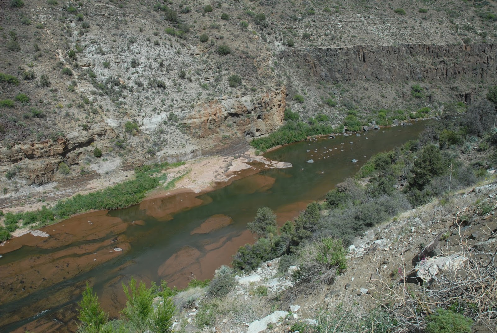 |
| The Salt River doesn’t rage like it did before the construction of Roosevelt Dam (1903-1911). |
Subscribe to:
Posts (Atom)