December 27, 2010 © Thomas J. Kollenborn. All Rights Reserved.
Read this article here.
Monday, December 27, 2010
Monday, December 13, 2010
Hollywood at the U Ranch
December 13, 2010 © Thomas J. Kollenborn. All Rights Reserved.
An old friend of mine wrote a book about the Superstition Wilderness Area and the many American Forestry Association trail rides he made into the area. John Dahlmann served as a representative for the American Forestry Association for more than twenty years. John had ridden horses on trail rides in many parts of the world including Alaska, Siberia, Morocco, Sinai Desert, and other interesting places. However, John's true love was the Superstition Wilderness Area and it's beauty. He rode with just about all of the outfitters from DeGraffenreid to Billy Clark Crader.
John had a special way of describing the Superstition Wilderness Area and it beauty as if it were part of his soul. He eventually moved to Apache Junction and retired in the area. John was born in 1911 and rode horses all his life. Trail riding was a way of life for John Dahlmann.
When John started riding with Billy and Rowean Crader in the late 1960's he ended up becoming friends with Ted and Marion De Grazia. Ted also enjoyed riding in the Superstition Wilderness Area. It was this common link that brought the two of them together. They eventually published a book together entitled A Tiny Bit Of God's Creation. John wrote the book and Ted furnished the artwork that included some of his Superstition Mountain sketches. Today this book is quite scarce and hard to find.
Not to long ago I was re-reading A Tiny Bit Of God's Creation and I came up on story John Dahlmann told about an old movie set near the Quarter U Ranch in Pinal Movie County near the end of the Peralta road off of U.S. Highway 60.
The site of this old movie set was approximately three-quarters of mile west of the Quarter Circle U Ranch.There is nothing remaining of the old movie set today. When I worked at the Quarter Circle U Ranch in the late fifties much of this old movie set was standing. The set was used for filming the 1957 movie, The Gunfight At The O.K. Corral starring Burt Lancaster and Angela Lansberry. A portion of the main street building props and buildings were still standing. Also the big old barn was standing across the street. This old movie set was a lease agreement between the State of Arizona and the movie industry. The Barkley's tried for several years to purchase the land used for the movie set and buildings.
John description of accidently walking into the movie set while they were filming is an interesting story. John tells the story something like this.
"We were going to Peralta Campground to hike up Peralta Canyon to Fremont Pass to get a good view of Weaver's Needle. It was at this point we saw something going on over near the Quarter Circle U Ranch. My curiosity dictated we should investigate.
We walked across the canyon from Peralta Trailhead due south for about a mile. It was a good thing we walked across. If we hadn't walked we would have been stopped. An Arizona Highway Patrolman was guarding the entrance to the Quarter Circle U Ranch for the film company. By walking onto the movie set dressed in our western apparel we were treated as part of the cast. We mingled on the set without being asked to leave. Burt Lancaster did not offer to shake our hand or mingle with us.
Our small group will never forget this adventure or the old movie set near the Quarter Circle U Ranch."
Over the years several movie were shot at this site, but I have not been able to find a list of those movies. Dean Martin and Jerry Lewis did a film shoot at the site for the movie Partners.
When Earle Stanley Gardner was in the area working on his book, Hunting Lost Mines By Helicopter, he used the old movie set for his headquarters. A few times we observed commercial photographs shooting material for advertisements.
Other than this the old site was not used after 1965. This old movie set eventual was torn down and hauled off because of neglect more than anything. Hopefully this old movie set will be remembered in the future and mentioned.
 |
| Movie set barn used on state lease land by film industry. |
John had a special way of describing the Superstition Wilderness Area and it beauty as if it were part of his soul. He eventually moved to Apache Junction and retired in the area. John was born in 1911 and rode horses all his life. Trail riding was a way of life for John Dahlmann.
When John started riding with Billy and Rowean Crader in the late 1960's he ended up becoming friends with Ted and Marion De Grazia. Ted also enjoyed riding in the Superstition Wilderness Area. It was this common link that brought the two of them together. They eventually published a book together entitled A Tiny Bit Of God's Creation. John wrote the book and Ted furnished the artwork that included some of his Superstition Mountain sketches. Today this book is quite scarce and hard to find.
Not to long ago I was re-reading A Tiny Bit Of God's Creation and I came up on story John Dahlmann told about an old movie set near the Quarter U Ranch in Pinal Movie County near the end of the Peralta road off of U.S. Highway 60.
 |
| The movie set on state land near Quarter Circle U Ranch. In 1957 The Gunfight At The O.K. Corral starring Burt Lancaster was filmed here. Photo by Dan Hopper. |
John description of accidently walking into the movie set while they were filming is an interesting story. John tells the story something like this.
"We were going to Peralta Campground to hike up Peralta Canyon to Fremont Pass to get a good view of Weaver's Needle. It was at this point we saw something going on over near the Quarter Circle U Ranch. My curiosity dictated we should investigate.
We walked across the canyon from Peralta Trailhead due south for about a mile. It was a good thing we walked across. If we hadn't walked we would have been stopped. An Arizona Highway Patrolman was guarding the entrance to the Quarter Circle U Ranch for the film company. By walking onto the movie set dressed in our western apparel we were treated as part of the cast. We mingled on the set without being asked to leave. Burt Lancaster did not offer to shake our hand or mingle with us.
Our small group will never forget this adventure or the old movie set near the Quarter Circle U Ranch."
Over the years several movie were shot at this site, but I have not been able to find a list of those movies. Dean Martin and Jerry Lewis did a film shoot at the site for the movie Partners.
When Earle Stanley Gardner was in the area working on his book, Hunting Lost Mines By Helicopter, he used the old movie set for his headquarters. A few times we observed commercial photographs shooting material for advertisements.
Other than this the old site was not used after 1965. This old movie set eventual was torn down and hauled off because of neglect more than anything. Hopefully this old movie set will be remembered in the future and mentioned.
Monday, December 6, 2010
Squaw Box Canyon Trail
December 6, 2010 © Thomas J. Kollenborn. All Rights Reserved.
The history of the Superstition Wilderness Area would be incomplete with a story about the Squaw Box Canyon trail, or better know as "Crazy Jake's" trail. Robert "Crazy Jake's" Jacob undoubtedly constructed this dangerous and notorious trail during the early 1970's to give him easier access to his diggings near the rim of the northwest end of Peter's Mesa at the head of Squaw Box Canyon. Jacob's original base camp was in some big boulders at the mouth of Squaw Box Canyon where it enters La Barge Canyon. The trip from his base camp to Jacob's digging site was about a half of a mile as the crow flies. Around 1983, maybe a little earlier, Jacob moved his camp from near La Barge Canyon to the top of Peter's Mesa.
The move required getting his camp from the bottom of Squaw Box Canyon to the top of Peter's Mesa. By 1985 Robert Jacob had five tents and a large camp established on Peter's Mesa a short distance from his diggings. Now outfitters had two options as to how to supply Jacob's Camp. They could bring in supplies from First Water Trailhead or Tortilla Trailhead. Either option was dangerous, difficult and tedious to say the least. Most pack strings required four to six pack animals. Either trip required three to five hours travel time one-way. Jake often took his investors in by the First Water Trailhead. Once they arrived at the base of Peter's Mesa in Squaw Box Canyon they were undecided about riding to the top of the rim to look at his camp or diggings. If you have ever sit on a horse at the beginning of the Squaw Box Canyon trail you would understand the consternation in one's mind before negotiating this trail to the top of Peter Mesa.
Originally there was a very primitive trail up through Squaw Box Canyon to the rim of Peter's Canyon. Old timers had followed a deer trail to the top. Jake had cleared and built up this trail in several spots making it possible to ride a horse over it while leading pack animals.
On Monday, May 18, 1987, Royal Norman, news weath-erman for Channel 3, Phoenix, departed on a five-day expedition into the Superstition Wilderness Area from Peralta Trailhead. Each evening Norman planned to transmit the weather live via microwave transmitter attached to a Bell Ranger helicopter to their Phoenix station. This was a very ambitious undertaking for a news reporting company. Most of the technology used was somewhat new and there were many variables. Royal Norman, expedition leader and news anchor, Brian Nellis, cameraman, and Ben Sobutian, sound technician were the Channel 3 crew. I was the expedition historian. Ron Feldman and I both served as guides. Ron and Jayne Feldman were the out-fitters with Bob Wright, Leroy Anderson and Robert Corbin going along on the expedition. Royal Norman interviewed a different person each news broadcast.
Our first evening was spent at White Rock in La Barge Canyon after a long day on the trail. The first broadcast was a success. The next morning we planned our next day's ride. After a little discussion it was decided to ride up Squaw Box Canyon trail ("Crazy Jake's" trail). Personally I had argued not to use the Squaw Box Canyon trail because it was quite rough the last time I was over it. However Ron felt it would be easier on the animals than the Peter's Mesa Trail above Charlebois Spring. Ron insisted we could make it up the trail. We made it, but what a price we paid.
The Squaw Box Canyon Trail climbs up the left hand canyon and up over the rim of Peter's Mesa.
Bob Corbin was swept off his horse by a large branch from a Mesquite tree, one of Ron Feldman's favorite horses almost made a leap into eternity off a cliff along the trail as we watched helplessly from above, and Royal Norman, the star of the production fell into an Agave plant that resulted in a painful puncture wound in his arm. After successfully making it to the top of Peter's Mesa on this trail we all agreed to stay off of it in the future.
Royal Norman's five-day expedition turned out to be a great success attesting to Ron Feldman's organizational and packing skills. Jayne Feldman prepared fine evening meals and had great lunches for the five days. After five days wandering through the Superstition Wilderness Area and visiting a variety of interesting landmarks such as Peter's Mesa, Tortilla Ranch, Roger's Canyon Cliff Dwellings, Circlestone and the Reavis Ranch everyone was ready to end this very successful expedition.
The thing that stood out most on this entire five-day expedition was the climb up Squaw Box Canyon trail. This trail had been eroded by summer rains and was overgrown by brush. The trail was extremely steep and very narrow in many places. Riding along the ledges near the rim of Peter's Mesa gave us the sensation of almost flying because the canyon was so far below and the trail was so narrow and close to the edge. We all survived it and I am sure none of us will ever forget "Crazy Jake's trail" or the Squaw Box Canyon trail.
This is another trail that will stand out in the annuals of Superstition Mountain history.
The history of the Superstition Wilderness Area would be incomplete with a story about the Squaw Box Canyon trail, or better know as "Crazy Jake's" trail. Robert "Crazy Jake's" Jacob undoubtedly constructed this dangerous and notorious trail during the early 1970's to give him easier access to his diggings near the rim of the northwest end of Peter's Mesa at the head of Squaw Box Canyon. Jacob's original base camp was in some big boulders at the mouth of Squaw Box Canyon where it enters La Barge Canyon. The trip from his base camp to Jacob's digging site was about a half of a mile as the crow flies. Around 1983, maybe a little earlier, Jacob moved his camp from near La Barge Canyon to the top of Peter's Mesa.
 |
| The Squaw Box Canyon Trail climbs up the left hand canyon and up over the rim of Peter's Mesa. |
Originally there was a very primitive trail up through Squaw Box Canyon to the rim of Peter's Canyon. Old timers had followed a deer trail to the top. Jake had cleared and built up this trail in several spots making it possible to ride a horse over it while leading pack animals.
On Monday, May 18, 1987, Royal Norman, news weath-erman for Channel 3, Phoenix, departed on a five-day expedition into the Superstition Wilderness Area from Peralta Trailhead. Each evening Norman planned to transmit the weather live via microwave transmitter attached to a Bell Ranger helicopter to their Phoenix station. This was a very ambitious undertaking for a news reporting company. Most of the technology used was somewhat new and there were many variables. Royal Norman, expedition leader and news anchor, Brian Nellis, cameraman, and Ben Sobutian, sound technician were the Channel 3 crew. I was the expedition historian. Ron Feldman and I both served as guides. Ron and Jayne Feldman were the out-fitters with Bob Wright, Leroy Anderson and Robert Corbin going along on the expedition. Royal Norman interviewed a different person each news broadcast.
Our first evening was spent at White Rock in La Barge Canyon after a long day on the trail. The first broadcast was a success. The next morning we planned our next day's ride. After a little discussion it was decided to ride up Squaw Box Canyon trail ("Crazy Jake's" trail). Personally I had argued not to use the Squaw Box Canyon trail because it was quite rough the last time I was over it. However Ron felt it would be easier on the animals than the Peter's Mesa Trail above Charlebois Spring. Ron insisted we could make it up the trail. We made it, but what a price we paid.
The Squaw Box Canyon Trail climbs up the left hand canyon and up over the rim of Peter's Mesa.
Bob Corbin was swept off his horse by a large branch from a Mesquite tree, one of Ron Feldman's favorite horses almost made a leap into eternity off a cliff along the trail as we watched helplessly from above, and Royal Norman, the star of the production fell into an Agave plant that resulted in a painful puncture wound in his arm. After successfully making it to the top of Peter's Mesa on this trail we all agreed to stay off of it in the future.
Royal Norman's five-day expedition turned out to be a great success attesting to Ron Feldman's organizational and packing skills. Jayne Feldman prepared fine evening meals and had great lunches for the five days. After five days wandering through the Superstition Wilderness Area and visiting a variety of interesting landmarks such as Peter's Mesa, Tortilla Ranch, Roger's Canyon Cliff Dwellings, Circlestone and the Reavis Ranch everyone was ready to end this very successful expedition.
The thing that stood out most on this entire five-day expedition was the climb up Squaw Box Canyon trail. This trail had been eroded by summer rains and was overgrown by brush. The trail was extremely steep and very narrow in many places. Riding along the ledges near the rim of Peter's Mesa gave us the sensation of almost flying because the canyon was so far below and the trail was so narrow and close to the edge. We all survived it and I am sure none of us will ever forget "Crazy Jake's trail" or the Squaw Box Canyon trail.
This is another trail that will stand out in the annuals of Superstition Mountain history.
Monday, November 15, 2010
Monday, November 1, 2010
Days of the Cowboy, Part II
November 1, 2010 © Thomas J. Kollenborn. All Rights Reserved.
Prior to roads and the horse drawn carriage the only means of travel between Superstition Mountain and the surrounding towns was by horseback or afoot. Since those long forgotten days little has changed within the boundaries of the Superstition Wilderness Area. Today one must still travel by foot or on horseback.
The Department of Agriculture set aside approximately 124,040 acres of land within the Tonto National Forest in 1939 to insure the preservation of natural wonders in the Sonoran Desert. This wilderness was increased in size in 1984 to 159,780 acres. Today a continuous flow of hikers and horseback riders travel these ancient Indian and early cattle trails to experience the isolation and tranquility of the Superstition Wilderness Area.
The cowboy was a significant part of this geographical region between 1870 and 1990. Only in the last decade or so were cattle permits removed from the Superstition Wilderness Area.
A herd, including cows, calves and a couple of bulls would be cared for by one cowboy. Most of these herds numbered between a hundred and three hundred head.
Each spring and fall a rodeo (roundup) was conducted to gather the cattle from the open range. The purpose of the roundup was to brand, castrate and doctor calves. Yearling steers were generally separated from the herd and driven to the nearest point of need. A typical roundup area consisted of temporary catch-pens, but most often it was open ground-work without the benefit of a corral.
Open ground-work consisted of roping a wild range calf, taking it away from its wild mother. Then you threw the calf to the ground while keeping the irate mother cow at bay, you then branded, castrated, dehorned and completed other necessary chores.
The cattle drovers and cattle barons of the Superstition Mountain area have long since disappeared. The great herds that once grazed the region under the brand of the Clemens Cattle Company and others have also vanished. At the peak of the Clemans operation more than 12,000 head of cattle grazed the eastern fringe of the wilderness.
These huge herds overgrazed and destroyed much of the range. Through the use of careful range management techniques much of the old range is returning to its original state. There are many controversies associated with grazing and non-grazing within the wilderness. Some range managers believe grazing helps to reduce wildfires while other believed that without wildfires the soil becomes infertile. This controversy continues among range managers today.
What distinguished a cowboy from other working men during this period? Cowboy's generally dressed a bit different then other workers because they worked outdoors most of the time. Large brimmed hats were common tools of the trade, Levi trousers, and heavy denim or cotton shirts, and of course pointed toed high top boots with extended heels were popular with cowboys. Cowboys often carried a rope, folding knife, bandana, chaps, and sometimes a Winchester rifle or Colt revolver. These items would probably best identify a range rider of that era.
Life was not easy on the open range, but it did have its rewards. Those old range riders may not have frequented churches very often, but they were close to their God and the work of his mighty hand. A cowboy's sense of freedom and free spirit while on the open range was unequaled anywhere else in the country. Cowboys rode through life uninterrupted by the complexities of urban society.
Cowboys generally didn't lie awake at night listening to sirens, bells and the noise of modern traffic. Their nights were filled with silence occasionally interrupted by the lonesome call of a coyote or other sounds of night. The cowboy recognized the value of sitting astride his horse and traveling with the wind in his face.
Hollywood has immortalized the free spirit of the American cowboy, helping to preserve some of the ideals of our freedom. These old time cowboys, and their horses were true icons of freedom and they definitely have a place in the history of the Superstition Wilderness Area and Americana. Hollywood certainly captured the persona of the American cowboy and his spirit and spread it across America.
The large cattle ranches of the Superstition Wilderness have long since vanished from the Arizona scene. Conservation methods did not destroy them. The high cost of operation, limited grazing and strict controls on public grazing lands have reduced the productivity of these once large cattle empires to almost nothing.
Feeder pens are slowly replacing the range beef of the past. Today only a few isolated ranches survive, symbolic of a time forgotten by many. Today men like Billy Martin Jr., George Martin, Frank Herron, and Chuck Backus try to hang on to the tradition of cattle ranching in the Superstition Mountain region.
These cattlemen and cowboys are certainly a part of the history of the Superstition Wilderness and our American heritage.
Prior to roads and the horse drawn carriage the only means of travel between Superstition Mountain and the surrounding towns was by horseback or afoot. Since those long forgotten days little has changed within the boundaries of the Superstition Wilderness Area. Today one must still travel by foot or on horseback.
 |
| Group of cowboys and their horses. Photo by H.R. Locke circa 1890. Denver Public Library, Western History Collection. |
The cowboy was a significant part of this geographical region between 1870 and 1990. Only in the last decade or so were cattle permits removed from the Superstition Wilderness Area.
A herd, including cows, calves and a couple of bulls would be cared for by one cowboy. Most of these herds numbered between a hundred and three hundred head.
Each spring and fall a rodeo (roundup) was conducted to gather the cattle from the open range. The purpose of the roundup was to brand, castrate and doctor calves. Yearling steers were generally separated from the herd and driven to the nearest point of need. A typical roundup area consisted of temporary catch-pens, but most often it was open ground-work without the benefit of a corral.
Open ground-work consisted of roping a wild range calf, taking it away from its wild mother. Then you threw the calf to the ground while keeping the irate mother cow at bay, you then branded, castrated, dehorned and completed other necessary chores.
The cattle drovers and cattle barons of the Superstition Mountain area have long since disappeared. The great herds that once grazed the region under the brand of the Clemens Cattle Company and others have also vanished. At the peak of the Clemans operation more than 12,000 head of cattle grazed the eastern fringe of the wilderness.
These huge herds overgrazed and destroyed much of the range. Through the use of careful range management techniques much of the old range is returning to its original state. There are many controversies associated with grazing and non-grazing within the wilderness. Some range managers believe grazing helps to reduce wildfires while other believed that without wildfires the soil becomes infertile. This controversy continues among range managers today.
What distinguished a cowboy from other working men during this period? Cowboy's generally dressed a bit different then other workers because they worked outdoors most of the time. Large brimmed hats were common tools of the trade, Levi trousers, and heavy denim or cotton shirts, and of course pointed toed high top boots with extended heels were popular with cowboys. Cowboys often carried a rope, folding knife, bandana, chaps, and sometimes a Winchester rifle or Colt revolver. These items would probably best identify a range rider of that era.
Life was not easy on the open range, but it did have its rewards. Those old range riders may not have frequented churches very often, but they were close to their God and the work of his mighty hand. A cowboy's sense of freedom and free spirit while on the open range was unequaled anywhere else in the country. Cowboys rode through life uninterrupted by the complexities of urban society.
Cowboys generally didn't lie awake at night listening to sirens, bells and the noise of modern traffic. Their nights were filled with silence occasionally interrupted by the lonesome call of a coyote or other sounds of night. The cowboy recognized the value of sitting astride his horse and traveling with the wind in his face.
Hollywood has immortalized the free spirit of the American cowboy, helping to preserve some of the ideals of our freedom. These old time cowboys, and their horses were true icons of freedom and they definitely have a place in the history of the Superstition Wilderness Area and Americana. Hollywood certainly captured the persona of the American cowboy and his spirit and spread it across America.
The large cattle ranches of the Superstition Wilderness have long since vanished from the Arizona scene. Conservation methods did not destroy them. The high cost of operation, limited grazing and strict controls on public grazing lands have reduced the productivity of these once large cattle empires to almost nothing.
Feeder pens are slowly replacing the range beef of the past. Today only a few isolated ranches survive, symbolic of a time forgotten by many. Today men like Billy Martin Jr., George Martin, Frank Herron, and Chuck Backus try to hang on to the tradition of cattle ranching in the Superstition Mountain region.
These cattlemen and cowboys are certainly a part of the history of the Superstition Wilderness and our American heritage.
Monday, October 18, 2010
A Last Stand, Part II
October 18, 2010 © Thomas J. Kollenborn. All Rights Reserved.
Read Part I here.
As I rode along a lonely trail toward Horse Camp Ridge in March of 19851 thought about the battles that once raged on the distant hilltops more than a hundred years ago. I wondered what kind of artifacts I might find if I could locate the place where a small band of Yavapai-Apache made a last stand in May of 1866. A place called Fortress Hill.
The directions I had to the hill were quite vague, however I knew the area well and felt I would recognized the hill from the description I had been given. The conical- shaped hill actually stood out among the many other hills in the area. As I rode toward the hill it fit the exact description I had been given.
The old man who told me about the hill described finding brass casings, lead balls and even a brass button or two. He said erosion had carried the artifacts down from the slopes of the hill. I was quite excited about what lay ahead as I quickly assembled my White Gold Master metal detector.
I began a systematic grid search of the lower slope of the hill. Within a few minutes I got my first beep. It was a brass casing and appeared to be a 45-90 cartridge. This find was followed by discoveries of more casings, lead mini-balls and one solitary brass button. I found some twenty mini-balls and almost as many brass cases. These artifacts indicated something had to have occurred on the top of this hill many years before my arrival. The metal detector had made myjob easier. I was convinced I had found Fortress Hill.
I had been told this story about a long forgotten hill in the heart of the Superstition Wilderness. I researched the military history of the area with the help of Joseph Crary and the United States Army Archives. I then traveled to the site to prove the old man's story. I was very fortunate and pleased to find relics from a battlefield dating back almost to the time of the American Civil War. It was so refreshing to hear a story about the Superstition Mountain area that actually panned out because most don't.
The discovery of these relics convinced me this battle occurred at this site. The discovery was also supported with military sketch maps of the area dating to the 1860's. This was an untold story of American history hidden deep in the Superstition Wilderness Area.
The artifacts found on Fortress Hill remain there today as part of a rich treasure trove of archaeological history. It is possible someday in the future Fortress Hill will be rediscovered and its story told.
The Superstition Wilderness Area is a treasure trove of historical and pre-historical artifacts and information. Federal law protects archaeological artifacts found in the Superstition Wilderness or on federal land. The removal of any artifacts including pottery shards, projectile points, or other historical objects construed to be fifty years or older is a violation of Federal Law. Please respect historical sites in this vast wilderness area that serves as an archaeological treasure trove.
Read Part I here.
As I rode along a lonely trail toward Horse Camp Ridge in March of 19851 thought about the battles that once raged on the distant hilltops more than a hundred years ago. I wondered what kind of artifacts I might find if I could locate the place where a small band of Yavapai-Apache made a last stand in May of 1866. A place called Fortress Hill.
The directions I had to the hill were quite vague, however I knew the area well and felt I would recognized the hill from the description I had been given. The conical- shaped hill actually stood out among the many other hills in the area. As I rode toward the hill it fit the exact description I had been given.
 |
| Desert Apaches from a photo circa 1903. |
I began a systematic grid search of the lower slope of the hill. Within a few minutes I got my first beep. It was a brass casing and appeared to be a 45-90 cartridge. This find was followed by discoveries of more casings, lead mini-balls and one solitary brass button. I found some twenty mini-balls and almost as many brass cases. These artifacts indicated something had to have occurred on the top of this hill many years before my arrival. The metal detector had made myjob easier. I was convinced I had found Fortress Hill.
I had been told this story about a long forgotten hill in the heart of the Superstition Wilderness. I researched the military history of the area with the help of Joseph Crary and the United States Army Archives. I then traveled to the site to prove the old man's story. I was very fortunate and pleased to find relics from a battlefield dating back almost to the time of the American Civil War. It was so refreshing to hear a story about the Superstition Mountain area that actually panned out because most don't.
The discovery of these relics convinced me this battle occurred at this site. The discovery was also supported with military sketch maps of the area dating to the 1860's. This was an untold story of American history hidden deep in the Superstition Wilderness Area.
The artifacts found on Fortress Hill remain there today as part of a rich treasure trove of archaeological history. It is possible someday in the future Fortress Hill will be rediscovered and its story told.
The Superstition Wilderness Area is a treasure trove of historical and pre-historical artifacts and information. Federal law protects archaeological artifacts found in the Superstition Wilderness or on federal land. The removal of any artifacts including pottery shards, projectile points, or other historical objects construed to be fifty years or older is a violation of Federal Law. Please respect historical sites in this vast wilderness area that serves as an archaeological treasure trove.
Monday, October 11, 2010
A Last Stand, Part I
October 11, 2010 © Thomas J. Kollenborn. All Rights Reserved.
You might say I enjoy recording historical events and also investigating them if they involve the Superstition Wilderness Area. I would like to tell you about a trip I made into the Superstition Wilderness in March, 1985, to check out a story about a military skirmish between the Army and the Apaches. An old friend told me about a small hill deep in the wilderness that once served as a refuge for a small band of Yavapai-Apache in May of 1866. This hill was located a short distance from another landmark known in military parlance as Dismal Valley.
Two Army infantry companies, the 14th and 32nd stationed at Fort McDowell, had cornered a small band of Apache-Yavapais, on a conical-shaped hill. None of the Native Americans planned to surrender a way of life they had known for generation e after generation. This was their "last stand." All of them fought to the death rather than become slaves of a culture foreign to their way of life. This is a inherit desire that is sometimes difficult for Anglo-Americans to understand about the first Americans.
For many years I had heard stories about the campaigns waged against the Apaches in the Superstition Mountains (Sierra Superstition).
I researched the topic, but failed to find much material. It wasn't until I met a gentleman named Joseph Crary that I was successful. Joe had done a considerable amount of research in and around Washington D.C. while in the U.S. Army. He found documentation involving military activities and campaigns in the Superstition Mountain and Salt River region. He found several military skirmish reports dating back to the mid-1860's.
Some of these reports revealed vivid descriptions of military action in the Superstition Mountain region by the U.S. Army against native Americans. Such places as Quail Camp, Dismal Valley, Picacho Butte, Coyote Tank and Fortress Hill were all disasters for the native Americans. The United States Army had only one soldier killed and three wounded in all of the Superstition Mountain skirmishes. The Yavapai-Apache fought these battles with bows, arrows, clubs, lances and a few outdated and primitive Mexican cap-lock muskets.
Some historians call this period between 1864-68 the Rancheria Campaign. The mission of the Army and Pima Scouts during this period was to search out and destroy the Yavapai-Apache villages. All men who resisted were to be killed and those who surrendered were to be placed on a reservation. The military reports indicated the body counts ranged from 11 to 53 dead at each of the Superstition villages that were raided.
The Army had destroyed the Apache-Yavapai villages in the Superstitions by 1868. Only raiding parties from San Carlos entered the Superstition area after 1868. The surrender of Geronimo in Skeleton Canyon near the Mexican border in 1886 ended the Indian Wars in Arizona Territory.
As I rode along a lonely trail toward Horse Camp Ridge I thought about the battles that once raged on the distant hilltops more than a hundred years ago. I wondered what kind of artifacts I might find if I could locate the place where a small band of Yavapai- Apache made a last stand in May of 1866. A place called Fortress Hill.
Read Part II here.
You might say I enjoy recording historical events and also investigating them if they involve the Superstition Wilderness Area. I would like to tell you about a trip I made into the Superstition Wilderness in March, 1985, to check out a story about a military skirmish between the Army and the Apaches. An old friend told me about a small hill deep in the wilderness that once served as a refuge for a small band of Yavapai-Apache in May of 1866. This hill was located a short distance from another landmark known in military parlance as Dismal Valley.
 |
| Tom Kollenborn searching Feeder's Mesa. |
For many years I had heard stories about the campaigns waged against the Apaches in the Superstition Mountains (Sierra Superstition).
I researched the topic, but failed to find much material. It wasn't until I met a gentleman named Joseph Crary that I was successful. Joe had done a considerable amount of research in and around Washington D.C. while in the U.S. Army. He found documentation involving military activities and campaigns in the Superstition Mountain and Salt River region. He found several military skirmish reports dating back to the mid-1860's.
Some of these reports revealed vivid descriptions of military action in the Superstition Mountain region by the U.S. Army against native Americans. Such places as Quail Camp, Dismal Valley, Picacho Butte, Coyote Tank and Fortress Hill were all disasters for the native Americans. The United States Army had only one soldier killed and three wounded in all of the Superstition Mountain skirmishes. The Yavapai-Apache fought these battles with bows, arrows, clubs, lances and a few outdated and primitive Mexican cap-lock muskets.
Some historians call this period between 1864-68 the Rancheria Campaign. The mission of the Army and Pima Scouts during this period was to search out and destroy the Yavapai-Apache villages. All men who resisted were to be killed and those who surrendered were to be placed on a reservation. The military reports indicated the body counts ranged from 11 to 53 dead at each of the Superstition villages that were raided.
The Army had destroyed the Apache-Yavapai villages in the Superstitions by 1868. Only raiding parties from San Carlos entered the Superstition area after 1868. The surrender of Geronimo in Skeleton Canyon near the Mexican border in 1886 ended the Indian Wars in Arizona Territory.
As I rode along a lonely trail toward Horse Camp Ridge I thought about the battles that once raged on the distant hilltops more than a hundred years ago. I wondered what kind of artifacts I might find if I could locate the place where a small band of Yavapai- Apache made a last stand in May of 1866. A place called Fortress Hill.
Read Part II here.
Monday, October 4, 2010
Cowboys and Windmills, Part II
October 4, 2010 © Thomas J. Kollenborn. All Rights Reserved.
Read Part I here.
As many an old rancher or Midwest fanner can tell you, windmills can be damn dangerous to the inexperienced. The old Barkley Ranch had several working (or partially working) windmills in the summer of 1955.
Windmill repair was still a necessary job on the ranch and required some skill. I was young and capable of climbing the windmill frame to service and work on these Aeromotors.
Wind was beginning to kick up a little and the thought of climbing up a windmill tower did not set to well with me. However, I wanted to please the boss and do my job as best I could. By the time I arrived at the base of the windmill the blades were spinning wildly. I pulled the release lever for the wind vane that kept the blades pointed away from the wind. The wind vane slammed into the blades, but finally the mill blades stopped turning.
The wind was still blowing quite hard when I climbed up the windmill frame. That was my first big mistake! By the time I reached the top windmill frame the wind was gusting and dust was so thick I couldn't see the ground. All of a sudden I realized how serious and hopeless my situation had become in just seconds. It was like riding a wild bull in an arena at night and the lights going out. Within seconds I was hanging on for dear life.
The wind must have been gusting up to about fifty miles per hour. Then all of a sudden thunder and lightning were crashing all around. The electrostatic discharge in the atmosphere raised the hair on my arms and on the back of my neck. I was told later that I served as great antenna for lightning on the top of that windmill tower. Raindrops pounded my bare flesh as soon as the dust storm subsided. My Mexican straw had probably blown back to Mexico. As I hung on for dear life and said a few prayers I couldn't see much of a future atop of the windmill frame, but I couldn't get down until the storm let up.
The storm roared on for about thirty minutes and finally the wind began to subside. I now knew how birds might have felt while riding out a windstorm in a tree. I had just ridden out a severe windstorm anchored to the top of windmill almost three and a half stories off the ground. My life of me I don't know how Stan Jones wrote the words for Ghost Rider's in the Sky while hanging on to a windmill during a thunderstorm in southern Arizona.
My experience that day taught me not to work on windmills during a windstorms or an electrical storm. The experience had made me far more conscience of the weather and its impact on humans. As a matter of fact, I learned to stay off windmills during any kind of storm. I could have been electrocuted or blown off the framework of the windmill and critically injured.
All of these experiences were about learning to be a cowboy and that was what I wanted most of all. As I continued to learn these various jobs I wondered if I would ever sit astride a horse and work cattle. That's what I thought cowboys did for a living. I soon found out that cowboys dug post holes, mended fences, built fence, cooked, worked on windmills, repair water holes, stacked hay, grained horses and none of these jobs required a man astride a horse. My vision of a cowboy had been shattered after all these ground jobs.
Recently I returned to the Quarter Circle U ranch, thanks to Chuck and Judy Backus, and as I rode by the upper windmill I reminisced about my experience there more than fifty years ago as a young, inexperienced, fearless, foolish buckaroo.
Yes, fear was an element in my senses, however it often didn't kick in until I was in grave danger of being injured or killed. As I grew older I began to respond to my senses and recognized dangerous situations, if for no other reason just out of fear.
Many of us were young and reckless once. We have been lucky to survive. Now as we grow older it is time to apply common sense and hopefully keep ourselves out of harms way. I wouldn't trade those days on the old Quarter U Ranch or those years in the service of my country for any other experiences in life. However, as I look back I can see why young men and women eagerly step forward to join the military and defend our country.
Most young people still don't know the meaning of fear until they experience it in the military or by a dangerous life-threatening experience. Learning to work on windmills was just another routine job on the old Quarter Circle U Ranch. You could always ask, "Was working as a cowboy really that dangerous?" I will always agree it can be hazardous if you're inexperienced.
Monday, September 27, 2010
Cowboys and Windmills
September 27, 2010 © Thomas J. Kollenborn. All Rights Reserved.
When you're young and trying to learn to be a cowboy there are several rules one should follow. First and most important is to listen and not be heard. When my boss Bill Barkley would explain and introduce me to a new skill for my cowboy experience I often found myself asking too many questions and not listening close enough to details. This was the case with stringing barbed wire, packing salt, digging postholes and working on Aeromotors or windmills.
As many an old rancher or Midwest farmer can tell you, windmills can be damn dangerous to the inexperienced. The old Barkley Ranch had several working (or partially working) windmills in the summer of 1955. I believe there were seven or Aeromotors windmills scattered over the 117 sections of rangeland that was the Barkley Cattle Company in the 1950s. After the demise of William A. Barkley in September of 1955, the ranch slowly began to decline. I worked during the twilight years of the Barkley dynasty. Windmill repair was still a necessary job on the ranch and required some skill. I was young and capable of climbing the windmill frame to service and work on these Aeromotors. I repaired the windmill at Don's Tank, the U Ranch, and Salt Tank several times. The mill's blades and gear cases were often shot full of holes by inconsiderate shooters or hunters. I replaced many windmill blades each summer. It always amazed me why the ignorant would vandalize such important equipment for pumping water to animals in such a dry arid region. In the Sahara Desert, if a man, or women damage a water-well it was a death penalty act.
I began my windmill apprenticeship in July of 1955. The temperature was somewhere around 108 degrees in the shade. Huge dark anvil shaped thunderclouds rose above the towering facade of the Dacite Cliffs north of the Quarter Circle U Ranch and to east over Coffee Flat. I had been instructed to check the windmill motors, oil them and then turn the tail vane parallel with the blades of the windmill so the winds of a thunderstorm would not damage them. This needed to be done only on the two at the Quarter Circle U Ranch. After all, these windmills provided the water we used at the ranch.
I climbed to the top of the windmill nearest the corral to quickly check the Aeromotor and then tie off the wind vane with the mill blades. I then climbed down to the ground and rushed down the pasture to the other windmill. I could see a storm was on its way.
Wind was beginning to kick up a little and the thought of climbing up on the lower windmill tower did not set to well with me. However, I wanted to please the boss and do my job as best I could. By the time I arrived at the base of the second windmill the blades were spinning wildly. I pulled the release lever for the wind vane chat kept the blades pointed away from the wind. The wind vane slammed into the blades, but finally the mill blades quite turning.
The wind was still blowing quite hard when I climbed up the windmill frame. That was my first big mistake! By the time I reached the top windmill frame thefwind was gusting and dust was so thick I couldn't see the ground. All of a sudden I realized how serious and hopeless my situation had become in just seconds. It was like riding a wild bull in an arena at night and the lights going out. Within seconds I was hanging on for dear life.
Read part II here.
When you're young and trying to learn to be a cowboy there are several rules one should follow. First and most important is to listen and not be heard. When my boss Bill Barkley would explain and introduce me to a new skill for my cowboy experience I often found myself asking too many questions and not listening close enough to details. This was the case with stringing barbed wire, packing salt, digging postholes and working on Aeromotors or windmills.
 |
| There were many windmills located on the old Barkley Ranches when I worked in the 1950s. This one was located along First Water Road where the Crosscut Trailhead is located today. Some historian claim barbed-wire, windmills, the Winchester rifle and the Colt single-action revolver tamed the West. |
I began my windmill apprenticeship in July of 1955. The temperature was somewhere around 108 degrees in the shade. Huge dark anvil shaped thunderclouds rose above the towering facade of the Dacite Cliffs north of the Quarter Circle U Ranch and to east over Coffee Flat. I had been instructed to check the windmill motors, oil them and then turn the tail vane parallel with the blades of the windmill so the winds of a thunderstorm would not damage them. This needed to be done only on the two at the Quarter Circle U Ranch. After all, these windmills provided the water we used at the ranch.
I climbed to the top of the windmill nearest the corral to quickly check the Aeromotor and then tie off the wind vane with the mill blades. I then climbed down to the ground and rushed down the pasture to the other windmill. I could see a storm was on its way.
Wind was beginning to kick up a little and the thought of climbing up on the lower windmill tower did not set to well with me. However, I wanted to please the boss and do my job as best I could. By the time I arrived at the base of the second windmill the blades were spinning wildly. I pulled the release lever for the wind vane chat kept the blades pointed away from the wind. The wind vane slammed into the blades, but finally the mill blades quite turning.
The wind was still blowing quite hard when I climbed up the windmill frame. That was my first big mistake! By the time I reached the top windmill frame thefwind was gusting and dust was so thick I couldn't see the ground. All of a sudden I realized how serious and hopeless my situation had become in just seconds. It was like riding a wild bull in an arena at night and the lights going out. Within seconds I was hanging on for dear life.
Read part II here.
Monday, September 20, 2010
Abe Reid: Prospector and Miner
September 20, 2010 © Thomas J. Kollenborn. All Rights Reserved.
As you ride into the brush thicket just above the confluence of Whitlow and Fraser Canyon you find two old shot up Aero windmills and concrete water tanks. Just above this site was the camp of Abraham "Abe" Reid. He had prospected and searched the Superstition Mountains off and on for the old Dutchman's lost mine. His friends knew him as "Abe". Abe had been in the mining and prospecting business since territorial days. He had worked around Globe, Miami and Ray since the turn of the century. He started work as a mucker and eventually worked his way up to a hard rock driller. By the early 1920's Abe was promoting mining property throughout the central mountain region of Arizona, in particular the area around Ray, Arizona and Mineral Creek. The stock market crash of 1929 sent Abe Reid into the mountains to eke out a living searching for gold. Abe promoted one property after another verily surviving the "depression years." Around 1935 Reid settled on a property some six and a half miles east of the Quarter Circle U Ranch. Reid called this mine the Silver Belle. Reid maintained a camp below the mine at a permanent source of water, known today as Reid's Water.
For almost twenty-two years Reid dug a tunnel into the side of the mountain on his claim. His work produced a large waste dump that is still visible today. Reid had a low grade silver ore deposit at the site, but it wasn't profitable to work. Reid spent a considerable amount of money building a road from the Silver Belle to Milk Ranch Creek. There was a road from the old Cavanaugh Milk Ranch to the Silver King Road. This road provided Abe Reid a route to and from his mine to haul supplies. It was possible to drive a high clearance pickup truck over the road from the Quarter Circle U Ranch through Coffee Flat to Reid's Water in the early 1960's. Around 1951, my father spent a weekend helping Abe Reid survey his tunnel and property. He was thinking about patenting the claims. However he decided against it because of annual property tax. While my dad worked, my mother and I stayed near his camp at Reid's Water. It was a beautiful spring morning for us. I remember the fresh green-yellow color of the early spring Cottonwood leaves, and most of all I recalled the magenta flowers of the Hedgehog cactus. It was from this experience that I remembered the character of Abe Reid and the beauty of the desert.
Abe was around seventy-two years old at the time. He had slowed down physically, but mentally he was prepared to dig forever in search of his bonanza of silver ore. My father wanted to help him continue that search even though dad knew it was fruitless. Abe was convinced his silver mine was a bonanza and he would someday hit pay dirt. Dad helped Reid because he liked him and had known him since before the "Great Depression Days."
Abe Reid always had three to eight burros he used in his prospecting and mining operation in Whitlow Canyon. Often Reid would be gone into the mountains for several days searching for the old Dutchman's gold mine. Contemporary storytellers mix Abe Reid into the Dutchman's Mine story with so many inaccuracies that it is obvious they are making up the story as they went along. Barry Storm wrote about Abe Reid prospecting throughout the Superstition Mountain region looking for the Dutchman's Lost Mine. From the "Great Depression" 1929-1938 Abe Reid spent a lot of time searching for the Dutchman's lost mine and digging his tunnel at the Silver Belle. Abe Reid was even mentioned as a plotter in the death of Adolph Ruth. If any of these individuals had actually known Abe Reid they would have known such a story was preposterous.
Abe Reid was always the topic of discussion when mining or the Dutchman's lost mine came up. Reid was known to hunt the Dutchman lost mine, sometimes with vigor, but after many years he settled on his silver claims near Whitlow Canyon and lived out his final years there. Fortunately Abe Reid told his story on magnetic tape and the recording has survived all these years. Today a copy of this tape survives at the Superstition Mountain Museum in Apache Junction, Arizona in the Abe Reid Collection. An old friend of Abe Reid's found him dead in his camp in October of 1958. Soon after Abe Reid's death the only accessible route to Reid property was through Queen Valley. It wasn't long before the road below Cavanaugh's old goat ranch was impassable in Milk Ranch Creek. Eventually the road through the Quarter Circle U Ranch was closed and Reid's old diggings became isolated from the modern world. A visit to Abe Reid's old mine today requires a vigorous hike up Whitlow Canyon from the Milk Ranch or a hike from the Peralta Trail Head through Castle Rock Divide then down to Whitlow Canyon from the opposite side. The last time I visited the area there was still water available in Reid's old campsite. At one time Abe had a network of corral at the site he kept his pack burros in. In my collection of Superstition Mountain artifacts I have one of Abe Reid's old burro packsaddles I acquired from George Martin. The legacy of Abe Reid focused on mining and prospecting in the Superstition Mountain region.
As you ride into the brush thicket just above the confluence of Whitlow and Fraser Canyon you find two old shot up Aero windmills and concrete water tanks. Just above this site was the camp of Abraham "Abe" Reid. He had prospected and searched the Superstition Mountains off and on for the old Dutchman's lost mine. His friends knew him as "Abe". Abe had been in the mining and prospecting business since territorial days. He had worked around Globe, Miami and Ray since the turn of the century. He started work as a mucker and eventually worked his way up to a hard rock driller. By the early 1920's Abe was promoting mining property throughout the central mountain region of Arizona, in particular the area around Ray, Arizona and Mineral Creek. The stock market crash of 1929 sent Abe Reid into the mountains to eke out a living searching for gold. Abe promoted one property after another verily surviving the "depression years." Around 1935 Reid settled on a property some six and a half miles east of the Quarter Circle U Ranch. Reid called this mine the Silver Belle. Reid maintained a camp below the mine at a permanent source of water, known today as Reid's Water.
 |
| Abe Reid standing near Fraser Canyon a short distance from his camp. This was about four years prior to his death. Photo courtesy of Dan Hopper, c. 1954 |
Abe was around seventy-two years old at the time. He had slowed down physically, but mentally he was prepared to dig forever in search of his bonanza of silver ore. My father wanted to help him continue that search even though dad knew it was fruitless. Abe was convinced his silver mine was a bonanza and he would someday hit pay dirt. Dad helped Reid because he liked him and had known him since before the "Great Depression Days."
Abe Reid always had three to eight burros he used in his prospecting and mining operation in Whitlow Canyon. Often Reid would be gone into the mountains for several days searching for the old Dutchman's gold mine. Contemporary storytellers mix Abe Reid into the Dutchman's Mine story with so many inaccuracies that it is obvious they are making up the story as they went along. Barry Storm wrote about Abe Reid prospecting throughout the Superstition Mountain region looking for the Dutchman's Lost Mine. From the "Great Depression" 1929-1938 Abe Reid spent a lot of time searching for the Dutchman's lost mine and digging his tunnel at the Silver Belle. Abe Reid was even mentioned as a plotter in the death of Adolph Ruth. If any of these individuals had actually known Abe Reid they would have known such a story was preposterous.
Abe Reid was always the topic of discussion when mining or the Dutchman's lost mine came up. Reid was known to hunt the Dutchman lost mine, sometimes with vigor, but after many years he settled on his silver claims near Whitlow Canyon and lived out his final years there. Fortunately Abe Reid told his story on magnetic tape and the recording has survived all these years. Today a copy of this tape survives at the Superstition Mountain Museum in Apache Junction, Arizona in the Abe Reid Collection. An old friend of Abe Reid's found him dead in his camp in October of 1958. Soon after Abe Reid's death the only accessible route to Reid property was through Queen Valley. It wasn't long before the road below Cavanaugh's old goat ranch was impassable in Milk Ranch Creek. Eventually the road through the Quarter Circle U Ranch was closed and Reid's old diggings became isolated from the modern world. A visit to Abe Reid's old mine today requires a vigorous hike up Whitlow Canyon from the Milk Ranch or a hike from the Peralta Trail Head through Castle Rock Divide then down to Whitlow Canyon from the opposite side. The last time I visited the area there was still water available in Reid's old campsite. At one time Abe had a network of corral at the site he kept his pack burros in. In my collection of Superstition Mountain artifacts I have one of Abe Reid's old burro packsaddles I acquired from George Martin. The legacy of Abe Reid focused on mining and prospecting in the Superstition Mountain region.
Monday, August 30, 2010
Monday, August 16, 2010
Wagon Tracks in Stone
August 16, 2010 © Thomas J. Kollenborn. All Rights Reserved.
Since I can remember there have been stories about wagon tracks in stone around or in the Superstition Wilderness Area. Some 60 years ago I heard a man telling my dad a story about some stone carreta tracks south of the wilderness boundary. A carreta was an old two-wheeled heavy-duty Spanish cart that could carry very large loads of the period. The man telling the story swore these were the tracks left behind, produced by two-wheeled carts carrying heavy loads of gold and silver bullion, back to Mexico from the rich mines around the Superstition Mountains.
My father talked to Jimmy Herron and Billy Martin Sr. about these alleged wagon tracks in stone. When dad first heard the story he didn't believe the Spanish hauled gold or silver bullion from this area back to Mexico in the 1840's. These ranchers knew exactly what the guy was talking about. They told dad exactly where the tracks were located and a little about their history.
According to Billy Martin Sr. the tracks were the results of the ore wagons hauling silver ore from the Silver King Mine to the Pinal Mill on Queen Creek just west of present day Superior. During the late 1870s and early 1880s there was a large milling op¬eration on the side of Queen Creek just west of Superior. The ore wagon road crossed a large deposit of welded volcanic tuff. This type of rock was not too resistant to the metal rims of the old wagon wheels carrying heavy loads of silver ore. The wagon wheels slowing etched two deep ruts across this large deposit of welded volcanic tuff (ash). This wagon wheel rut reveals the years of transport over this route from the Silver King Mine to the old Pinal Mill.
The old Silver King Mine was discover in 1875 and developed into one of the largest and richest of the early silver mines in Arizona Territory. At first the mine owners tried to ship ore to Yuma then down to the Gulf of California and on to San Francisco. This method of shipment was far too expensive. A mill was constructed on Pinal Creek west of Superior in the late 1870's where the ore was processed much cheaper and made the Silver King a very profitable mining operation. Today little remains of the old Silver King mine. Forty years ago I took some photos up at the Silver King that included the old mine superintendent office. Today the building is gone. All that remains of the Pinal Mill along Queen Creek is parts of its foundation. The history of the area is etched in the ash just north of the mill along the road to the old Silver King Mine where the wagons crossed a long de¬posit of volcanic tuff. Sorry treasure hunters, these are not carreta tracks made by the Mexican Or Spanish pioneers of the Southwest.
The turnoff to the Wagon Tracks is about halfway between the Boyce Thompson Arboretum and Superior along Highway 60 on the right side of the highway. A visit to the wagon tracks is a wonderful historical reminder of the past mining history of Arizona Territorial days. The State of Arizona should preserve this unique site for future generations to see.
Since I can remember there have been stories about wagon tracks in stone around or in the Superstition Wilderness Area. Some 60 years ago I heard a man telling my dad a story about some stone carreta tracks south of the wilderness boundary. A carreta was an old two-wheeled heavy-duty Spanish cart that could carry very large loads of the period. The man telling the story swore these were the tracks left behind, produced by two-wheeled carts carrying heavy loads of gold and silver bullion, back to Mexico from the rich mines around the Superstition Mountains.
 |
| These are the wagon tracks in stone. I am pointing to the tracks of the lead mules that is also in stone. As you stand silently over these old stone tracks you can almost here the teamster cracking the whip and the mules trudging along pulling their heavy loads. |
According to Billy Martin Sr. the tracks were the results of the ore wagons hauling silver ore from the Silver King Mine to the Pinal Mill on Queen Creek just west of present day Superior. During the late 1870s and early 1880s there was a large milling op¬eration on the side of Queen Creek just west of Superior. The ore wagon road crossed a large deposit of welded volcanic tuff. This type of rock was not too resistant to the metal rims of the old wagon wheels carrying heavy loads of silver ore. The wagon wheels slowing etched two deep ruts across this large deposit of welded volcanic tuff (ash). This wagon wheel rut reveals the years of transport over this route from the Silver King Mine to the old Pinal Mill.
The old Silver King Mine was discover in 1875 and developed into one of the largest and richest of the early silver mines in Arizona Territory. At first the mine owners tried to ship ore to Yuma then down to the Gulf of California and on to San Francisco. This method of shipment was far too expensive. A mill was constructed on Pinal Creek west of Superior in the late 1870's where the ore was processed much cheaper and made the Silver King a very profitable mining operation. Today little remains of the old Silver King mine. Forty years ago I took some photos up at the Silver King that included the old mine superintendent office. Today the building is gone. All that remains of the Pinal Mill along Queen Creek is parts of its foundation. The history of the area is etched in the ash just north of the mill along the road to the old Silver King Mine where the wagons crossed a long de¬posit of volcanic tuff. Sorry treasure hunters, these are not carreta tracks made by the Mexican Or Spanish pioneers of the Southwest.
The turnoff to the Wagon Tracks is about halfway between the Boyce Thompson Arboretum and Superior along Highway 60 on the right side of the highway. A visit to the wagon tracks is a wonderful historical reminder of the past mining history of Arizona Territorial days. The State of Arizona should preserve this unique site for future generations to see.
Sunday, August 15, 2010
Jesse Capen Is Missing
August 15, 2010 © Thomas J. Kollenborn. All Rights Reserved.
Some time around the first week of December 2009, a young man embarked on trip to search for a lost gold mine in Arizona. He chose the Tortilla Creek drainage basin of the Superstition Wilderness Area. Some time after that and prior to December 20, 2009, Jesse Capen went missing.
On December 20, 2009, a white Jeep wagon was found abandoned at the Upper Tortilla Ranch Windmill. The vehicle was reportedly owned by Capen of Denver, Colo. He was 35 years old, 6 feet 4 inches tall and weighed 204 lbs. He worked as a bell hop for the Downtown Denver Sheraton hotel.
The Maricopa County Sheriff's Office contacted Capen's mother, Cynthia Burnett and she reported Jesse was in Arizona looking for a lost mine in the Superstition Mountains. She said he had driven to Arizona after Thanksgiving.
On December 22, 2009, somewhere in the area of Indian Springs, Jesse's camp was checked. Capen's wallet, credit cards, cash, iPod, backpack, food and water were found in his tent. The Maricopa County Sheriff's Office conducted a search of the area throughout the month of December finding no sign of Jesse.
Search dogs, SAR members, deputies and a helicopter search the areas marked on a map found in Jesse's tent. All of this effort produced no clues as to what happened to Jesse. The area where Jesse went missing was hit by a severe winter storm between November 22-23, 2009, and blew down many trees in the area including a large Cottonwood tree near Kane Springs.
The entire region around Indian and Kane Springs northwestward toward Tortilla Mountain is extremely rough and very treacherous terrain. I worked round up in this area in the 1950s and it is difficult to even spot cows in this country let alone an injured man. Elmer Pope, an old Apache cowboy who worked for Floyd Stone, once told me this was the roughest cattle range he had ever worked.
There are several vertical prospects that are eight to 15 feet deep in the area. Elmer had covered several of them and fenced in others to keep cattle from falling in them. There were several prospects and old tunnels over toward Night Hawk Springs.
What happen to Jesse Capen? Did he fall into some prospect hole, fall off of a boulder, slip and fall of off of the trail? Did he injure himself jumping, from one boulder to another? Or did he hike on over to Pistol Canyon on Peter's Mesa and become disoriented and injured in that area? Or did he change his mind and hike up toward the top of Tortilla he wanted to search and was injured? Maybe he just decided to walk out the other side of the mountain and disappear off the face of the Earth? Speculation continues to aggravate the search.
Who was Jesse Joseph Capen? His mother reported him to be a gentle giant. He didn't even consider carrying a firearm into the mountains. He had collected over 100 books on the Superstition Mountains and the Dutchman's Lost mine. He had downloaded all the information he could find about the Waltz's mine from the Internet and carefully organized it. Jesse was single and had never married. His mother Cynthia Burnett said he never really talked about the Dutchman's Lost Mine and the Superstition Mountains in Arizona. She also revealed on an Internet forum her son was bi-polar.
Searching with even good information can be difficult at best. Over the years, I have been involved with five or six major searches. All of them but two ended tragically. One young man was angry at his father and decided to teach him a lesson by hiding from searchers for more than a week.
Another young man was angry at his grandmother and remained lost during the heat of July in the mountains for almost a week before he walked out to the search command post at the Peralta Trail Head. He was very familiar with the area. He knew where an old mine tunnel was that had a spring in.
These types of experiences can callous ones initiative to participate in such searches for missing people. Volunteers continue being involved in search and rescue because they know most missing people did not intend to become lost or injured. However the largest majority of searches end finding or saving the missing person. Sadly enough a few search and rescue efforts end tragically.
We must all take a moment to thank the many volunteers of the many search and rescue groups in Arizona and our nation. They are on call 24 hours a day from their jobs, families and friends. However, without them many lives would have been lost over the years. The search is never over until a rescue is made or the remains are recovered. The volunteer knows this is what brings closure for a family of a love one who has been lost. This is the reason we have so many wonderful people involved in search and rescue.
Jesse will be brought home eventually.
Some time around the first week of December 2009, a young man embarked on trip to search for a lost gold mine in Arizona. He chose the Tortilla Creek drainage basin of the Superstition Wilderness Area. Some time after that and prior to December 20, 2009, Jesse Capen went missing.
 |
| Jesse Capen of Denver, Colo., has been missing in the Superstitions since December 2009. |
The Maricopa County Sheriff's Office contacted Capen's mother, Cynthia Burnett and she reported Jesse was in Arizona looking for a lost mine in the Superstition Mountains. She said he had driven to Arizona after Thanksgiving.
On December 22, 2009, somewhere in the area of Indian Springs, Jesse's camp was checked. Capen's wallet, credit cards, cash, iPod, backpack, food and water were found in his tent. The Maricopa County Sheriff's Office conducted a search of the area throughout the month of December finding no sign of Jesse.
Search dogs, SAR members, deputies and a helicopter search the areas marked on a map found in Jesse's tent. All of this effort produced no clues as to what happened to Jesse. The area where Jesse went missing was hit by a severe winter storm between November 22-23, 2009, and blew down many trees in the area including a large Cottonwood tree near Kane Springs.
The entire region around Indian and Kane Springs northwestward toward Tortilla Mountain is extremely rough and very treacherous terrain. I worked round up in this area in the 1950s and it is difficult to even spot cows in this country let alone an injured man. Elmer Pope, an old Apache cowboy who worked for Floyd Stone, once told me this was the roughest cattle range he had ever worked.
There are several vertical prospects that are eight to 15 feet deep in the area. Elmer had covered several of them and fenced in others to keep cattle from falling in them. There were several prospects and old tunnels over toward Night Hawk Springs.
What happen to Jesse Capen? Did he fall into some prospect hole, fall off of a boulder, slip and fall of off of the trail? Did he injure himself jumping, from one boulder to another? Or did he hike on over to Pistol Canyon on Peter's Mesa and become disoriented and injured in that area? Or did he change his mind and hike up toward the top of Tortilla he wanted to search and was injured? Maybe he just decided to walk out the other side of the mountain and disappear off the face of the Earth? Speculation continues to aggravate the search.
Who was Jesse Joseph Capen? His mother reported him to be a gentle giant. He didn't even consider carrying a firearm into the mountains. He had collected over 100 books on the Superstition Mountains and the Dutchman's Lost mine. He had downloaded all the information he could find about the Waltz's mine from the Internet and carefully organized it. Jesse was single and had never married. His mother Cynthia Burnett said he never really talked about the Dutchman's Lost Mine and the Superstition Mountains in Arizona. She also revealed on an Internet forum her son was bi-polar.
Searching with even good information can be difficult at best. Over the years, I have been involved with five or six major searches. All of them but two ended tragically. One young man was angry at his father and decided to teach him a lesson by hiding from searchers for more than a week.
Another young man was angry at his grandmother and remained lost during the heat of July in the mountains for almost a week before he walked out to the search command post at the Peralta Trail Head. He was very familiar with the area. He knew where an old mine tunnel was that had a spring in.
These types of experiences can callous ones initiative to participate in such searches for missing people. Volunteers continue being involved in search and rescue because they know most missing people did not intend to become lost or injured. However the largest majority of searches end finding or saving the missing person. Sadly enough a few search and rescue efforts end tragically.
We must all take a moment to thank the many volunteers of the many search and rescue groups in Arizona and our nation. They are on call 24 hours a day from their jobs, families and friends. However, without them many lives would have been lost over the years. The search is never over until a rescue is made or the remains are recovered. The volunteer knows this is what brings closure for a family of a love one who has been lost. This is the reason we have so many wonderful people involved in search and rescue.
Jesse will be brought home eventually.
Monday, August 9, 2010
Charley Boy or Charlebois
August 9, 2010 © Thomas J. Kollenborn. All Rights Reserved.
The Superstition Wilderness Area has many historical sites that have played a role in the history of Arizona Territory. Charlebois Spring is such a site. This idyllic and verdant oasis situated deep within the Superstition Wilderness Area has attracted humans for a millennium. The spring has always been a good source for permanent water in the mountains. Prior to the lowering of the valley water table by agriculture Charlebois Spring provided enough water for a year around garden. The spring is located in Charlebois Canyon approximately nine miles southeast of First Water trailhead along the Charlebois-First Water Trail (also known as the Dutchman Trail FS 104). The spring is located among a large stand of Cottonwood and Sycamore trees off La Barge Canyon in a side canyon called Charlebois Canyon.
Petroglyphs (pictoglyphs) located a short distance from the spring in La Barge Canyon attest to prehistoric man's use of the region. These petroglyphs depict successful hunting forays by the early inhabitant of the region. The military, prospectors, cattlemen and treasure hunters followed the Native Americans in this area. Many treasure hunters have a misconception that these pictoglyphs are Spanish treasure symbols. Considering the fact the Spanish were never in these mountains should be convincing enough. However, there are always those who skirt the facts and believe the unlikely.
Soldiers from the 14th, 24th, and 32nd Infantries out of Fort McDowell campaigned against the Apache and Yavapai who sought sanctuary in these mountains after raiding ranches and farms in the Salt River Valley. The soldiers at Fort McDowell knew these mountains as the Sierra Superstitions. Several of these campaigns were started in late May and early June of 1864. Charlebois Spring became an important source of water for man and beast during these early skirmishes. Prospectors and cattlemen soon followed the soldiers in the mid 1870s after the Apaches and Yavapais were subdued in the area. Some of these prospectors risked death prior to 1886 in their search for gold in the area.
Originally Charlebois Spring was called Black Mountain Spring, or Alamo Spring according to some sources. However, later the spring was named after a French-Canadian cattleman named Martin Charlebois. This was around the turn of the 19th century. Mart, as he was known, ran cattle in the area for several years. Charlebois eventually built a cabin at the spring. He also had an extensive terraced garden under the Cottonwoods and Sycamores he irrigated with water from the spring. Charlebois lived in the area for several years packing all his supplies in from Florence or Mesa.
This original cabin built by Charlebois burned down in the early 1920s. William A. Barkley owner and operator of the Barkley Cattle Company from 1907-1955 rebuilt the cabin and used it as a line camp for many years. The cabin and spring served as a base of operation during the search for Adolph Ruth in the summer of 1931.
The tin cabin Barkley built was torn down in 1948 by Jimmy Ruiz and Grady Haskins, then moved to Bluff Springs were the cabin was reconstructed. The cabin then was used for storing salt blocks and hay. The old Charlebois cabin stood there until 1962, when the Tonto National Forest required the cabin's removal from the Superstition Wilderness Primitive Area.
Martin Charlebois was a territorial pioneer who suffered the hardships and rigors of this hostile land. It is only fitting that a canyon, spring and mountain bear his name today. Some time ago a bureaucrat tried to convince me there was no history associated with the Superstition Wilderness Area worthy of preservation. I adamantly disagreed with him. The truth is there are hundreds of stories about men and women who came here to eke out a living and raise a family. Their lives and tribulations are the history of this vast mountain wilderness. Each decade more and more pioneer names of landmarks are removed from maps of the Superstition Wilderness Area. Eventually few names of these pioneers will exist on the maps of this region.
The Superstition Wilderness Area has many historical sites that have played a role in the history of Arizona Territory. Charlebois Spring is such a site. This idyllic and verdant oasis situated deep within the Superstition Wilderness Area has attracted humans for a millennium. The spring has always been a good source for permanent water in the mountains. Prior to the lowering of the valley water table by agriculture Charlebois Spring provided enough water for a year around garden. The spring is located in Charlebois Canyon approximately nine miles southeast of First Water trailhead along the Charlebois-First Water Trail (also known as the Dutchman Trail FS 104). The spring is located among a large stand of Cottonwood and Sycamore trees off La Barge Canyon in a side canyon called Charlebois Canyon.
Petroglyphs (pictoglyphs) located a short distance from the spring in La Barge Canyon attest to prehistoric man's use of the region. These petroglyphs depict successful hunting forays by the early inhabitant of the region. The military, prospectors, cattlemen and treasure hunters followed the Native Americans in this area. Many treasure hunters have a misconception that these pictoglyphs are Spanish treasure symbols. Considering the fact the Spanish were never in these mountains should be convincing enough. However, there are always those who skirt the facts and believe the unlikely.
 |
| This ancient petroglyph near Charlebois Canyon that depict a hunting scene is called a Master Map by treasure hunters. |
Originally Charlebois Spring was called Black Mountain Spring, or Alamo Spring according to some sources. However, later the spring was named after a French-Canadian cattleman named Martin Charlebois. This was around the turn of the 19th century. Mart, as he was known, ran cattle in the area for several years. Charlebois eventually built a cabin at the spring. He also had an extensive terraced garden under the Cottonwoods and Sycamores he irrigated with water from the spring. Charlebois lived in the area for several years packing all his supplies in from Florence or Mesa.
 |
| The site of the old cabin at Charlebois Spring. The area was terraced for gardening. This photo was taken during the winter and the trees had no leaves on them. |
The tin cabin Barkley built was torn down in 1948 by Jimmy Ruiz and Grady Haskins, then moved to Bluff Springs were the cabin was reconstructed. The cabin then was used for storing salt blocks and hay. The old Charlebois cabin stood there until 1962, when the Tonto National Forest required the cabin's removal from the Superstition Wilderness Primitive Area.
Martin Charlebois was a territorial pioneer who suffered the hardships and rigors of this hostile land. It is only fitting that a canyon, spring and mountain bear his name today. Some time ago a bureaucrat tried to convince me there was no history associated with the Superstition Wilderness Area worthy of preservation. I adamantly disagreed with him. The truth is there are hundreds of stories about men and women who came here to eke out a living and raise a family. Their lives and tribulations are the history of this vast mountain wilderness. Each decade more and more pioneer names of landmarks are removed from maps of the Superstition Wilderness Area. Eventually few names of these pioneers will exist on the maps of this region.
Monday, July 12, 2010
Return to the Cave of a Thousand Eyes
July 12, 2010 © Thomas J. Kollenborn. All Rights Reserved.
The "Cave of a Thousand Eyes" surely had other names, but I am not privileged with that information. However, I am amazed this semi-wet cave has survived into the 21st century with very little damage. The cave was announced to world in 1935 when a local prospector reported finding a diamond mine in the Superstition Mountains.
I visited the cave about 14 years ago and you could still see the spot where Joe Modock found his so-called "diamond treasure." When I climbed through the entrance of the cavern it was almost closed with loose debris and well concealed from the streambed below. I sincerely believed the beauty of this cavern needed to be protected from vandals so I carefully completed the closure of the opening by piling broken pieces of limestone over the entrance as I departed for final time. Modock and Jose Perez ventured only a few hundred feet into the limestone cavern. It wasn't until the early 1970s this cave was explored by two amateur spelunkers. The explorers climbed through about 1,200 feet of narrow caverns and chambers before giving up because of water. The cave is not a wet cave by caving criteria; however the cave has a significant amount of water in it. The water may come from an underground spring or from a seep during the rainy season.
I made another visit to the cave this year and found no evidence of anyone being in the cave or any damage in the entrance area. Hopefully the cave will remain undiscovered for another couple of decades until it can properly be protected. My GPS coordinates are accurate within 10 foot. I had often wondered if anyone could find it with my GPS coordinates. The entrance is so well closed with limestone rocks and a good stand of Manzanita. The Manzanita covers the entrance of the cave making it difficult to see standing within ten feet of it. Limestone caverns are quite rare within the boundaries of the Superstition Wilderness Area because most of the wilderness is compose of intrusive or extrusive igneous rocks. Only small portions of the wilderness include sedimentary rock. The most prominent areas of sedimentary rocks are found along the Haunted Canyon drainage and its tributaries.
Early cattlemen of the area undoubtedly knew about these various lime stone caves in this region because they probably chased Mountain lions into these caves with dogs. The Mountain lions preyed on their cattle and had to be destroyed when they could be found. An old time cowboy lion hunter told me he once took over forty lions out-of this country in one year. The only way these old cowboys could be successful killing lions was using good tracking and scent hounds.
The names Moraga, and even Jose Perez (Periz) have been attached to the names of some caverns in the area. Both Frank Moraga and Jose Perez (Periz) homesteaded in the region along Pinto Creek between 1910-1916. Eventually the homesteads were proven up and they received title to their land. Frank Moraga probably was the first man to really explore the cavern. Jose Perez (Periz) also entered the cave and then several months later returned with the Gila County engineer. Perez was convinced he had discovered the Dutchman's Lost Mine. The next man to explore the cavern was Joe Modock in 1935. He claimed he had found a diamond mine in the Superstition Mountains. As it turned out, he had a sack of Calcite crystals he had broken off the wall of the cavern. The diamond mine story was short-lived when local discovered the diamonds were Calcite crystals. This is a brief history on the cavern, but it gives the reader some of the available information. Information about this cavern can be found in the Mesa Journal Tribune c. 1935, and the Arizona Republican, c. 1916.
The Haunted Canyon and Pinto Creek area has some very interesting history associated with it. Cattle, homesteading, and mining have played an important role in this slowly developing area. The large open pit mine east of the region has consumed many of the local landmarks. One of the truly interesting landmarks was Gold Rush Creek. This was site was the source of a lot of free gold prior the open pit mining in the area. Today, fine gold can still occasionally be found in Pinto Creek, however most of the creek is staked out with current claims.
The "Cave of a Thousand Eyes," Moraga Cave or Periz's Cave all are probably one in the same. As far as I know the cavern is still in pristine condition other than the damage done by Modock when he broke of the Calcite crystals on the travertine wall about 300 feet from the entrance of "Grand Chamber" and at least 200 feet from the entrance. Hopefully the entrance of this cavern will remain unknown to the general public and therefore it may survive into another century.
The "Cave of a Thousand Eyes" surely had other names, but I am not privileged with that information. However, I am amazed this semi-wet cave has survived into the 21st century with very little damage. The cave was announced to world in 1935 when a local prospector reported finding a diamond mine in the Superstition Mountains.
 |
| The Cave is located in the drainage of the Haunted Canyon near the old Tony (Toney) Ranch. Photo c. 1979. |
I made another visit to the cave this year and found no evidence of anyone being in the cave or any damage in the entrance area. Hopefully the cave will remain undiscovered for another couple of decades until it can properly be protected. My GPS coordinates are accurate within 10 foot. I had often wondered if anyone could find it with my GPS coordinates. The entrance is so well closed with limestone rocks and a good stand of Manzanita. The Manzanita covers the entrance of the cave making it difficult to see standing within ten feet of it. Limestone caverns are quite rare within the boundaries of the Superstition Wilderness Area because most of the wilderness is compose of intrusive or extrusive igneous rocks. Only small portions of the wilderness include sedimentary rock. The most prominent areas of sedimentary rocks are found along the Haunted Canyon drainage and its tributaries.
Early cattlemen of the area undoubtedly knew about these various lime stone caves in this region because they probably chased Mountain lions into these caves with dogs. The Mountain lions preyed on their cattle and had to be destroyed when they could be found. An old time cowboy lion hunter told me he once took over forty lions out-of this country in one year. The only way these old cowboys could be successful killing lions was using good tracking and scent hounds.
The names Moraga, and even Jose Perez (Periz) have been attached to the names of some caverns in the area. Both Frank Moraga and Jose Perez (Periz) homesteaded in the region along Pinto Creek between 1910-1916. Eventually the homesteads were proven up and they received title to their land. Frank Moraga probably was the first man to really explore the cavern. Jose Perez (Periz) also entered the cave and then several months later returned with the Gila County engineer. Perez was convinced he had discovered the Dutchman's Lost Mine. The next man to explore the cavern was Joe Modock in 1935. He claimed he had found a diamond mine in the Superstition Mountains. As it turned out, he had a sack of Calcite crystals he had broken off the wall of the cavern. The diamond mine story was short-lived when local discovered the diamonds were Calcite crystals. This is a brief history on the cavern, but it gives the reader some of the available information. Information about this cavern can be found in the Mesa Journal Tribune c. 1935, and the Arizona Republican, c. 1916.
The Haunted Canyon and Pinto Creek area has some very interesting history associated with it. Cattle, homesteading, and mining have played an important role in this slowly developing area. The large open pit mine east of the region has consumed many of the local landmarks. One of the truly interesting landmarks was Gold Rush Creek. This was site was the source of a lot of free gold prior the open pit mining in the area. Today, fine gold can still occasionally be found in Pinto Creek, however most of the creek is staked out with current claims.
The "Cave of a Thousand Eyes," Moraga Cave or Periz's Cave all are probably one in the same. As far as I know the cavern is still in pristine condition other than the damage done by Modock when he broke of the Calcite crystals on the travertine wall about 300 feet from the entrance of "Grand Chamber" and at least 200 feet from the entrance. Hopefully the entrance of this cavern will remain unknown to the general public and therefore it may survive into another century.
Monday, July 5, 2010
Our Museum: A Special Place
July 5, 2010 © Thomas J. Kollenborn. All Rights Reserved.
The community of Apache Junction lies nestled beneath the towering facade of world famous Superstition Mountain. This giant monolith and the infamous Dutchman's Lost mine has carried Apache Junction and Arizona into the limelight of national and international news for numerous decades.
The history and legend of this mountain has motivated more than a hundred authors to write books on the subjects of Superstition Mountain, the Dutchman's Lost Mine, Lost Peralta Gold or the beauty of the Sonoran Desert.
Television cameras have broadcasted these stories across the airways of the nation and the world. Not too long ago, Arizona Senator John McCain commented on the unique history of this mountain wilderness and how proud he was about having a part in helping to preserve the historical society, once it was area for an A & E documentary as he stood at the base of Superstition Mountain Lost Dutchman State Park on Wednesday, January 21, 1998. Tourists, residents, and visitors are still fascinated with the history and legend of this mountain.
The idea of a museum being constructed and dedicated to the history of Superstition Mountain and the Dutchman's Lost Mine was conceived seventy years ago. However, this idea wasn't put into action. In mid-November of 1978, the idea of a museum in the Apache Junction area again emerged from idle conversation. This discussion generated the energies of individuals who wanted to fulfill the dream of a museum about Superstition Mountain and the adjacent area.
The greatest obstacle for the historical society, once it was formed and incorporated, was finding a building to display artifacts and exhibits. Finally in the spring of 1989, Mr. Robert Schoose and partners, at the Goldfield Ghost Town Tours, Inc., offered the historical society a home for the museum. The agreement included a two-story 3,500 square foot building on an ideal location in the ghost town overlooking the Apache Trail and with Superstition Mountain to the east. The grand opening of the new museum took place on Saturday, January 30, 1990 after many months of hard work.
The historical society members gathered a variety of items to represent the history of the region. Some of the items included Hohokam stick figures, an excellent mineral collection, a 1904 Apache Trail road marker, maps, books, gold specimens, era items such as an 1898 bicycle, a 20 stamp gold mill for crushing gold ore, and etc. The museum captures a sequence of time from the prehistoric to contemporary in a very small space. The museum also contains a collection of art and photographs of the region. The museum book store has one of the finest selections of reading material on the Superstition Mountain and Arizona.
Museum displays contain a variety of topics ranging from history to geology, fauna to flora and maps to legends. The museum was both entertaining and educational.
Eventually the museum outgrew Goldfield and the board of directors decided to move the facility to the museum's thirteen acres near Mountain View Road and the Apache Trail. The ground breaking for the new museum occurred on Friday, at 3:00 P.M. on January 3, 2003. The grand opening of the new museum was held on Thursday, at 4:30 P.M. December 4, 2004.
The primary goal of this museum has been to preserve and present the history, geology, flora, fauna and lore of the Superstition Wilderness Area. This new museum has an outstanding collection on the history of this region. Men like Jack Anderson, George Curtiss, Barney Barnard and even my father dreamed of Apache Junction someday having a museum dedicated to Superstition Mountain and the Lost Dutchman Mine. A group of modern day visionaries made this museum a reality by 1990. The opening of the new facility in 2003 has insured a future for the preservation of Superstition Mountain and Lost Dutchman Mine history and legend.
For more information about the museum call (480) 983- 4888, write the Superstition Mountain Historical Society, P.O. Box 3845, Apache Junction, Arizona, 85117 or email to SuperstitionMountainMuseum.org.
The community of Apache Junction lies nestled beneath the towering facade of world famous Superstition Mountain. This giant monolith and the infamous Dutchman's Lost mine has carried Apache Junction and Arizona into the limelight of national and international news for numerous decades.
The history and legend of this mountain has motivated more than a hundred authors to write books on the subjects of Superstition Mountain, the Dutchman's Lost Mine, Lost Peralta Gold or the beauty of the Sonoran Desert.
Television cameras have broadcasted these stories across the airways of the nation and the world. Not too long ago, Arizona Senator John McCain commented on the unique history of this mountain wilderness and how proud he was about having a part in helping to preserve the historical society, once it was area for an A & E documentary as he stood at the base of Superstition Mountain Lost Dutchman State Park on Wednesday, January 21, 1998. Tourists, residents, and visitors are still fascinated with the history and legend of this mountain.
The idea of a museum being constructed and dedicated to the history of Superstition Mountain and the Dutchman's Lost Mine was conceived seventy years ago. However, this idea wasn't put into action. In mid-November of 1978, the idea of a museum in the Apache Junction area again emerged from idle conversation. This discussion generated the energies of individuals who wanted to fulfill the dream of a museum about Superstition Mountain and the adjacent area.
The greatest obstacle for the historical society, once it was formed and incorporated, was finding a building to display artifacts and exhibits. Finally in the spring of 1989, Mr. Robert Schoose and partners, at the Goldfield Ghost Town Tours, Inc., offered the historical society a home for the museum. The agreement included a two-story 3,500 square foot building on an ideal location in the ghost town overlooking the Apache Trail and with Superstition Mountain to the east. The grand opening of the new museum took place on Saturday, January 30, 1990 after many months of hard work.
The historical society members gathered a variety of items to represent the history of the region. Some of the items included Hohokam stick figures, an excellent mineral collection, a 1904 Apache Trail road marker, maps, books, gold specimens, era items such as an 1898 bicycle, a 20 stamp gold mill for crushing gold ore, and etc. The museum captures a sequence of time from the prehistoric to contemporary in a very small space. The museum also contains a collection of art and photographs of the region. The museum book store has one of the finest selections of reading material on the Superstition Mountain and Arizona.
Museum displays contain a variety of topics ranging from history to geology, fauna to flora and maps to legends. The museum was both entertaining and educational.
Eventually the museum outgrew Goldfield and the board of directors decided to move the facility to the museum's thirteen acres near Mountain View Road and the Apache Trail. The ground breaking for the new museum occurred on Friday, at 3:00 P.M. on January 3, 2003. The grand opening of the new museum was held on Thursday, at 4:30 P.M. December 4, 2004.
 |
| The Supersitition Mountain Lost Dutchman Museum is located 3 1/2 miles NE of Apache Junction at 4087 N. Apache Trail. Get a feeling of what the Old West was really like. The museum has a variety of exhibits and is open 383 days a year. |
For more information about the museum call (480) 983- 4888, write the Superstition Mountain Historical Society, P.O. Box 3845, Apache Junction, Arizona, 85117 or email to SuperstitionMountainMuseum.org.
Monday, June 28, 2010
Bob Ward: A Walk With the Past
June 28, 2010 © Thomas J. Kollenborn. All Rights Reserved.
Those of you who knew of Robert Lee Ward believed him to be a mountain man extraordinary. This is something no one could really deny him.
For some 30 years, Bob Ward hiked the trails of the Superstition Wilderness Area. He loved the mountains, the desert and stories that lingered there. I doubt I will ever meet anyone else who was so enthralled about the "wild" American West. The first time I met Bob he had his entire family over at Apache Land watching a western gunfight show.
Bob was here one day then gone the next. It happened so suddenly, even though I had known him for 30 years. He called me friend, I suppose because I loved the mountain and its history also. I called him friend because he was an undeniable part of these mountains. I did not like the mountains with the intensity he did, but I was totally absorbed with gathering the history and stories associated with them. When you listened to Bob he sounded like "lord of his domain," the Superstition Mountains. Treasure hunters came from around the country to talk to Bob Ward about his theories associated with the Peralta Stone Maps.
Bob's theory associated with hidden treasure in the Superstition Mountains centered on the Peralta Stone Maps. Ward believed in these stone maps with a very strong conviction that they were totally authentic. Bob was totally convinced he had deciphered the lines, marks and numbers on the stones. He made a presentation to me on a full moonlight night almost 30 years ago and even then I couldn't accept his theory. However, I didn't discourage his belief in the gold or the so-called Peralta Stone Maps of the Superstition Mountains.
I recall how excited Bob was when George Johnston and Clay Worst agreed to go on an expedition to see how he interpreted the Peralta Stone Maps. Bob guided the two men along the trail he believed to be the stone map trail. The trail Bob believed would eventually lead to the treasure of Superstition Mountain.
The 1970s passed, then the 1980s and by the 1990s I could see Bob's health was rapidly failing. I tried to encourage him to give up the cigarettes and the booze, but he couldn't do it. The cigarettes were slowly, killing him. The last 15 years of Bob Ward's life was spent living in or in close proximity of Superstition Mountain. Bob lived anywhere he could pitch a tent or build a lean-to. In 1984, Bob moved into an old cabin on a mining claim near the old Burn's Ranch on Peralta Road. He spent the next six years living in the cabin while Don Hensley tried to patent the claims the cabin was setting on. Bob made any place his home, whether it was a tent, old cabin or lean-to. He was a very clever and intelligent man. Bob was an excellent writer and a very good artist. He had a very good sense of humor that went a long way.
Ward in his final years tried to convince anyone who would listen that his theory about the stone maps was correct. I denied these attempts because I totally disagreed with the authenticity of the so-called Peralta Stone Maps. Ward believed these maps to be authentic and I believed them to be a hoax. Even though I disagreed with him, we still remained friends over the years. We both loved the same mountain, its history, legend and lore.
Bob's final days were spent trying to assemble his version of the lost gold of Superstition Mountain into a believable history for the people in the Apache Junction area. He had tried this with his Superstition Territory newsletter he printed off and on. I do believe Bob Ward accomplished this task when John Denmark published his book, The Ripples of Lost Echos. Bob was proud of his book and talked about it with me on several occasions.
Those of you who knew of Robert Lee Ward believed him to be a mountain man extraordinary. This is something no one could really deny him.
For some 30 years, Bob Ward hiked the trails of the Superstition Wilderness Area. He loved the mountains, the desert and stories that lingered there. I doubt I will ever meet anyone else who was so enthralled about the "wild" American West. The first time I met Bob he had his entire family over at Apache Land watching a western gunfight show.
Bob was here one day then gone the next. It happened so suddenly, even though I had known him for 30 years. He called me friend, I suppose because I loved the mountain and its history also. I called him friend because he was an undeniable part of these mountains. I did not like the mountains with the intensity he did, but I was totally absorbed with gathering the history and stories associated with them. When you listened to Bob he sounded like "lord of his domain," the Superstition Mountains. Treasure hunters came from around the country to talk to Bob Ward about his theories associated with the Peralta Stone Maps.
Bob's theory associated with hidden treasure in the Superstition Mountains centered on the Peralta Stone Maps. Ward believed in these stone maps with a very strong conviction that they were totally authentic. Bob was totally convinced he had deciphered the lines, marks and numbers on the stones. He made a presentation to me on a full moonlight night almost 30 years ago and even then I couldn't accept his theory. However, I didn't discourage his belief in the gold or the so-called Peralta Stone Maps of the Superstition Mountains.
 |
| Bob Ward at his cabin on Peralta Road c. 1984 |
The 1970s passed, then the 1980s and by the 1990s I could see Bob's health was rapidly failing. I tried to encourage him to give up the cigarettes and the booze, but he couldn't do it. The cigarettes were slowly, killing him. The last 15 years of Bob Ward's life was spent living in or in close proximity of Superstition Mountain. Bob lived anywhere he could pitch a tent or build a lean-to. In 1984, Bob moved into an old cabin on a mining claim near the old Burn's Ranch on Peralta Road. He spent the next six years living in the cabin while Don Hensley tried to patent the claims the cabin was setting on. Bob made any place his home, whether it was a tent, old cabin or lean-to. He was a very clever and intelligent man. Bob was an excellent writer and a very good artist. He had a very good sense of humor that went a long way.
Ward in his final years tried to convince anyone who would listen that his theory about the stone maps was correct. I denied these attempts because I totally disagreed with the authenticity of the so-called Peralta Stone Maps. Ward believed these maps to be authentic and I believed them to be a hoax. Even though I disagreed with him, we still remained friends over the years. We both loved the same mountain, its history, legend and lore.
Bob's final days were spent trying to assemble his version of the lost gold of Superstition Mountain into a believable history for the people in the Apache Junction area. He had tried this with his Superstition Territory newsletter he printed off and on. I do believe Bob Ward accomplished this task when John Denmark published his book, The Ripples of Lost Echos. Bob was proud of his book and talked about it with me on several occasions.
Monday, June 21, 2010
Monday, June 7, 2010
Linesba's Lost Dutchman Mine
May 31, 2010 © Thomas J. Kollenborn. All Rights Reserved.
William W. Linesba, a mine operator from the Prescott area, became very interested in the Superstition Mountain area in late 1937. From November 1939 through April 1940 Linesba employed several miners from Superior, Arizona in a mining operation on the southwestern corner of Bluff Springs Mountain in the Superstition Primitive Area, later called the Superstition Wilderness Area and a part of the Tonto National Forest. This mine became known as the Lost Dutchman Mine No. I. Actually these were old diggings when Linesba's crew reopened them.

Linesba and his crew of miners staked out almost a square mile of mining claims in the area. Within this square mile Linesba believed the Lost Dutchman Mine was located. He was convinced these old diggings near the southwestern edge of Bluff Springs Mountain were Mexican in origin. Linesba had heard stories about Mexican prospectors in the area from old timers around Florence. He searched for the old diggings and located them. His development of these old diggings resulted in a small permanent camp a short distance from the shaft. The camp was located below Bluff Springs Mountain in a saddle between Bark Draw and Bluff Spring's Mountain Canyon.
When I was a young man my father took me by this old camp on several occasions. The first time I visited the camp I recalled seeing the wooden floors used for the tent cabins. I am not sure exactly what year this was, but it was in the late 1940s. There were four or five tent houses in the William's Camp. I was told the camp was named after Linesba's first name. Other sources have said the camp was named after a man that worked for Linesba named Charley Williams. Williams supposedly found a cache of gold bullion in the 1930s. As late as 1973 you could still find large pieces of the lumber used for these old tent house floors.
At the old prospect site there is still as very deep vertical shaft. The shaft is reported to exceed 120 feet in depth. Linesba had an excellent head frame and hoist system set up at the shaft. The waste dump exhibits considerable excavation while revealing no indication of minerals or profitable ore. This site certainly was not the Lost Dutchman Mine. These diggings left nothing but a scar on the natural beauty of the region. The shaft is not filled in to this day and is an extremely danger place to wander around.
William W. Linesba eventually built a small stone cabin at the entrance of Peralta (Willow) Canyon near a good source of water in 1939. After his death Linesba's wife lived in the cabin for several years.
I don't recall exactly the year the old Linesba Cabin was torn down, but I know it was still standing in 1959, the last year I worked for the Quarter Circle U Ranch.
Linesba didn't find the Dutchman's Lost Mine and like many others, he was very disappointed about his investment in the mine and the money other people had lost.
William W. Linesba died of natural causes in the Hotel La Posada in Holbrook, Arizona on Monday, June 10, 1941. According to the obituary, Linesba was a mining man from Prescott, but was well known around Holbrook because he spent time shipping Manganese ore from a mine in Long Valley near Prescott. His wife and daughter of Florence Junction survived him. Florence Junction is where his wife picked up her mail.
Linesba left his mark on the history of the Superstition Wilderness Area. His legacy will be remembered by all of those who recalled his Lost Dutchman Mine No. 1. This operation marked his legacy in the area near the base of Bluff Springs Mountain.
'Sunset' Gardner
June 7, 2010 © Thomas J. Kollenborn. All Rights Reserved.
Each Saturday morning back in the mid-'70s, I listened to the "Sunset" Gardner Show on KSTM Radio in Apache Junction. How many of you remember the "Sunset" Gardner Show on KSTM Radio?
I had been teaching at the Apache Junction Jr. High School for about three years at the time. I listened to the show because Gardner often featured students from the Apache Junction Jr. High School on his show that had some speaking or singing talent. Our students would do weather forecast, sing songs, recite poetry and announce school events and news. Gardner worked hard to make his Saturday morning show a success. The show was very popular among parents and grand parents in Apache Junction. In fact, parents, teachers, community leaders often tuned to KSTM to hear the "Sunset" Gardner Show to express encouragement to students who participated.
I was involved with "Sunset" Gardner in a variety of community projects over the years. He was always willing to volunteer his time for community projects. There was the radio show on KSTM Radio with Ron Harkins, a variety show at Superstition Mountain Elementary School's auditorium, the talent show each year at SMES, the Apache Junction Public Events Series, and Senior Citizens Day. "Sunset" helped me on many occasions with my Prospecting the Superstitions Class I taught through Central Arizona College at night. He often rode along as a chaperone for my Jr. High School horseback field trip into the Superstition Mountains, adding a special dimension of knowledge to these trips. He was a very strong community minded individual and constantly worked to improve the community. I fondly remember "Sunset" Gardner and his ancient Gibson guitar as he played many our favorite old western tunes.
There was another, adventurous side to "Sunset" Gardner that I wasn't aware of at the time. He was an adamant searcher of the Lost Dutchman Mine. He had roamed the Superstition Wilderness Area since the early 1950s looking for the old "Dutchman" gold. To my amazement neither my father nor I had met him before. When Gardner lost his life in a tragic motorcycle accident on September 17, 1983, in Mesa, I learned a lot about his background. A close family friend gave me some photographs of "Sunset" when he was looking for the Dutchman's Mine around Weaver's Needle. These photographs included images of Edgar Piper, and his entire crew. The images linked "Sunset" with an interesting era of Superstition Mountain history. "Sunset" tried to convince both sides that bloodshed wasn't the answer to their problems. However both sides talked about killing the other side. That was the feud between Maria Jones and Edgar Piper 1956 through 1963.
I will never forget the time I was on the south end of Black Top Mesa with a couple of friends. We were inspecting and photographing the old tunnel dug by Hank and Henry Harnish and others in the early 1960s. I found a rock with a freshly carved map on it. The map was called the "Lost Donkey Mine Map," and shortly after I found the map we heard some rocks and debris tumbling down the slope of from the top of Black Top Mesa. We soon saw "Sunset" and one his friends approaching the entrance of the overhang we were standing under. This was an unusual meeting in the mountains between individuals so interested in the history and legend of the region. "Sunset" admitted he carved the "Donkey Map" and I admitted I found it. I still have the old stone "Donkey Map" "Sunset" carved that day while eating lunch on the side of Black Top Mesa.
"Sunset" Garner's life has a special niche in the history of Apache Junction and Superstition Mountain. His stories, laughter, and music will always be a part of this community's history. Many of us will never forget his desire to help children and his community. When he died, I was asked to deliver his ashes to their final resting-place, which I am not at liberty to reveal.
I only hope my final resting-place will equal the beauty, solitude and tranquility of "Sunset." Vaya con dios mi amiga.
Each Saturday morning back in the mid-'70s, I listened to the "Sunset" Gardner Show on KSTM Radio in Apache Junction. How many of you remember the "Sunset" Gardner Show on KSTM Radio?
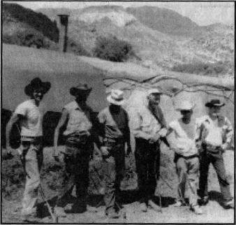 |
| Sunset Gardner is standing on the left in this photo of Ed Piper's Camp c. 1959. Piper is the third from the right. Piper had quite a camp near the base of Weaver's Needle as you can see by the large military tent in the background. |
I was involved with "Sunset" Gardner in a variety of community projects over the years. He was always willing to volunteer his time for community projects. There was the radio show on KSTM Radio with Ron Harkins, a variety show at Superstition Mountain Elementary School's auditorium, the talent show each year at SMES, the Apache Junction Public Events Series, and Senior Citizens Day. "Sunset" helped me on many occasions with my Prospecting the Superstitions Class I taught through Central Arizona College at night. He often rode along as a chaperone for my Jr. High School horseback field trip into the Superstition Mountains, adding a special dimension of knowledge to these trips. He was a very strong community minded individual and constantly worked to improve the community. I fondly remember "Sunset" Gardner and his ancient Gibson guitar as he played many our favorite old western tunes.
There was another, adventurous side to "Sunset" Gardner that I wasn't aware of at the time. He was an adamant searcher of the Lost Dutchman Mine. He had roamed the Superstition Wilderness Area since the early 1950s looking for the old "Dutchman" gold. To my amazement neither my father nor I had met him before. When Gardner lost his life in a tragic motorcycle accident on September 17, 1983, in Mesa, I learned a lot about his background. A close family friend gave me some photographs of "Sunset" when he was looking for the Dutchman's Mine around Weaver's Needle. These photographs included images of Edgar Piper, and his entire crew. The images linked "Sunset" with an interesting era of Superstition Mountain history. "Sunset" tried to convince both sides that bloodshed wasn't the answer to their problems. However both sides talked about killing the other side. That was the feud between Maria Jones and Edgar Piper 1956 through 1963.
I will never forget the time I was on the south end of Black Top Mesa with a couple of friends. We were inspecting and photographing the old tunnel dug by Hank and Henry Harnish and others in the early 1960s. I found a rock with a freshly carved map on it. The map was called the "Lost Donkey Mine Map," and shortly after I found the map we heard some rocks and debris tumbling down the slope of from the top of Black Top Mesa. We soon saw "Sunset" and one his friends approaching the entrance of the overhang we were standing under. This was an unusual meeting in the mountains between individuals so interested in the history and legend of the region. "Sunset" admitted he carved the "Donkey Map" and I admitted I found it. I still have the old stone "Donkey Map" "Sunset" carved that day while eating lunch on the side of Black Top Mesa.
"Sunset" Garner's life has a special niche in the history of Apache Junction and Superstition Mountain. His stories, laughter, and music will always be a part of this community's history. Many of us will never forget his desire to help children and his community. When he died, I was asked to deliver his ashes to their final resting-place, which I am not at liberty to reveal.
I only hope my final resting-place will equal the beauty, solitude and tranquility of "Sunset." Vaya con dios mi amiga.
Monday, May 31, 2010
The Lost Dutchman Mine Inc.
May 24, 2010 © Thomas J. Kollenborn. All Rights Reserved.
Shortly after World War I, George Miller met Dr. Robert Alexander Aiton. The medical doctor had a strong inter-est in mine development and promotion. Aiton was looking for a mine and the right prospector to promote when he met Miller and his partners, John Hluper and Ernest Martin. Aiton found Miller's story about gold in the area interesting. The question remains to this day. Did Aiton know there was no gold or did he really believe there was gold in the area? Either way he became the fundraiser for the corporation he named the Lost Dutchman Mine Inc.
Dr. Aiton appointed Miller president of the company, Hluper, vice president and himself, secretary-treasurer. Aiton also had another man working for the Lost Dutchman Mine Corp. Inc. who was named James G. Simpson. He was in charge of data and publicity. Aiton set up an office at 33 N. Second Ave. in Phoenix and had stock certificates printed and on sale for the Lost Dutchman Mine Corp. almost immediately. Aiton had a prospectus printed to encourage people to purchase stock in the rich Lost Dutchman Mine. He called the character of the mine, "the richest gold strike of re-cent years in Arizona." The Arizona Gazette ran an article on August 20,1920, revealing a rich gold discovery at the Miller Mine. The article was titled "Rich Strike Made In Lost Dutchman." Aiton also printed the results of an as-say sample that revealed gold ore that had approximately five ounces of gold to the ton. The sample was called No. 1 Red Ore. The sample was a rhyolitic breccia containing iron and manganese oxides. The oxides were limonite and pyrolusite. The assayer was Charles A. Diehl.
I often visited with Diehl in the mid 1950s while attending high school, to talk about gold mines and treasures in Arizona's Mountains. He told me the Miller Mine was salted. However, he further stated he didn't know who was responsible for the salting. He stood by George Miller's character and integrity claiming he Was an honest man. ("Salting" a gold mine was done to make a worthless claim appear rich and rewarding with the sprinkling of a little gold dust to show prospective buyers.) Dr. Robert A. Aiton claimed an old prospector rediscovered the Lost Dutchman Mine. The prospector's name was George Miller, who was now president of Aiton's company the Lost Dutchman Mine, Inc. Aiton was 64 years old at the time the Arizona Republic article appeared in 1920 about his problems with the Arizona Medical Board since his arrival in Arizona Territory in 1899. Aiton, whose home was in Superior was an excellent promoter. He raised sufficient capital for the development of the Miller Mines (Lost Dutchman Mine Inc.). By mid-1921 there was a head-frame, power station, and five-man crew working at the mine. A shaft had been sunk and a drift driven 150 feet into the earth. Aiton was so convinced there was gold at the site in 1921 he told in-vestors they would strike the main vein soon. Investors continued to pour money into the operation and Aiton continued to talk about riches beyond belief. Aiton had an excellent promotional pamphlet printed for investors.
The operation continued for five years off and on, but never produced any valuable ore. There had been no gold from the very beginning. However, George Miller and John Hluner's property. The Lost Dutchman Mine Inc. failed.
Who was Dr. Robert A. Aiton? He was born in Illinois in 1858, came to the Arizona Territory in 1899 and eventually moved from Phoenix to Superior with his family. He and his wife, Rose, had four sons and five daughters. Aiton had practiced medicine through out central Arizona and was one of Arizona's pioneer doctors. However he was often in conflict with the Arizona Board of Medical Practitioners.
Aiton became involved with the Miller Mines when he was 62 years old, shortly after 1918. He and Rose lived in Superior until the time of his death on Monday, February 17, 1928. He is buried in Superior.
George "Drakulich" Miller died on April 6,1'936, and was buried by a group of cowboys on a small wind swept hill above his mine. John Hluper died in 1934 and was buried at the mine also. Ernest Martin died in 1927 and was also buried on the mining claims. Miller wanted to be buried near his prospecting partners Hluper and Martin.
This was the story three old men in their twilight years hanging on to a dream of golden riches and in their final days saw hope in the promotion skills of Dr. Robert A. Aiton. They never found their bonanza, but they did leave us with an epic tale of dedication and survival in the middle of a wilderness.
Monday, May 24, 2010
Wednesday, May 5, 2010
Superstition Gold Stories
May 5, 2010 © Thomas J. Kollenborn. All Rights Reserved.
There are more stories about lost gold and large gold caches within the boundaries of the Superstition Wilderness Area than contained in all the treasure books of the Americas. But the United States Geological Service reports no profitable deposit of minerals are available within the wilderness area, with the exception of perlite or similar building material that results from deposit of welded volcanic ash a common product of a volcanic eruption. Many years ago there were reports from the USGS that reported deep-seated mineral deposits below 5,000 feet. Apparently none of these deposits proved economical or profitable to work after a Canadian company did some deep-seat drilling near the old JF Ranch. One drill site penetrated the earth's surface some 8,700 feet without favorable results.
Now, how about the many gold stories told. I have heard the story of Jacob Waltz and his mine since I was a child. Oh yes, his mine was so rich you could carve pure gold out of an eighteen inch vein with a knife. Also there was enough gold in sight at the mine to make twenty men multi-millionaires. These tales from the 1890's continue to fascinate men and women today. Sometime around 1920 Dr. Robert Alexander Aiton claimed he was opening the Lost Dutchman Mine, Inc., some sixty miles east of Phoenix. Newspaper articles of the period attested to the rich ore discovered at the Miller Mine (Lost Dutchman Mine.) By 1929 this story proved to be a stock scam and finally witnessed its' own demise.
Another interesting story involved a World War I veteran who discovered a cave in the Superstition Mountains filled with gold nuggets. Charley Williams disappeared in the Superstition Primitive Area in 1935. Williams, a crippled veteran was reported missing January 5, 1935. For several days it was feared Williams was dead. On January 8, 1935 Williams emerged from the mountains with a pocket full of gold nuggets and a strange story of how they were discovered. Williams told how he entered a cave and bumped his head. As he sat on the floor of the cave he scooped up these golden pebbles. As it turned out they were gold nuggets. When the nuggets were analyzed they turned out to be dental gold. The U.S. Government confiscated the nuggets under the U.S. Gold Act and planned to prosecute Williams for hoarding gold. Williams had more than five ounces of gold. The U.S. Government kept the illegal gold and Williams was not prosecuted. This was basically the end of the story.
Early in the 1950's another treasure story jumped up on the Southwestern stage. This story involved a strange set of stone maps found near Florence Junction. According to those who claimed they could interpret these stone maps, the maps supposedly led to a bonanza of gold. These maps have since fueled many horrendously fraudulent claims that helped relieve many investors of their hard earned savings.
First, there was Clarence O. Mitchell, (Travis Marlowe) and his M.O.E.L. Corporation in the 1960's. The infamous M.O.E.L. Corporation was followed by Robert Simpson "Crazy Jake" Jacob, and his claim of discovering several metric tons of gold bullion in Squaw Box Canyon. Jacob was eventually convicted of fraud and sentenced to ten years in prison. He also admitted at his trial he never had such a treasure in the Super-stition Mountains. The Arizona Attorney General's office estimated Jake relieved his investors of more than eight million dollars over a period of nine years. Robert Simpson Jacob was a man with a "golden tongue."
There were several incidental purveyors of the Peralta Stone Maps after the M.O.E.L. Corporation and Robert "Crazy Jake" Jacob. Many of these individual believed in the credibility of the "stone maps." Unfortunately investors have lost millions of dollars being involved with people who claim they have solved the "mystery of the Peralta Stone Maps. Charles "Chuck" A. Crawford was a big promoter of the Stone Maps and claimed to have located the "end of the trail" in the Upper La Barge Box at the old mining claims of Roy Bradford. Bob Corbin and I visited his site in the early 1980's. Chuck and his investor were convinced they had found the hidden gold of the Peralta family. Chuck never really had a job; he used his investor's money to promote his own agenda. Ironically Crawford's legacy continues today even after his death.
To this day investors continue to invest money in the Stone Maps. Ironically if the stone maps were authentic the United States Government would have confiscated them years ago under the national antiquity act. If they were authentic we would be looking at them in the Smithsonian Museum under early American history. Yes, there is a remote possibility that there might be deep-seated gold veins within the Superstition Wilderness, but for the most part what little bit of gold that is found in the wilderness is microscopic and of no real economic value. For those who insist on throwing their money away on tall stories about lost gold in the Superstition Wilderness Area all I can recommend is don't plan on writing it off on your taxes. There is no legitimate mining operation going on in the Superstition Wilderness Area presently. As far as the record shows the only Trove Treasure permit ever issued for the wilderness area was to Ronald Feldman of the O.K. Corral in 2004 for a dig near Iron Mountain.
The history and legacy of this mountain continues to attract those who dream of riches even beyond the scope of Frank J. Dobie's book Coronado's Children. We all probably have dreamed about discovery a lost gold mine or treasure, but the reality of these dreams is nothing comes easy in this world of work. Wealth is generated by hard work and good planning.
There are more stories about lost gold and large gold caches within the boundaries of the Superstition Wilderness Area than contained in all the treasure books of the Americas. But the United States Geological Service reports no profitable deposit of minerals are available within the wilderness area, with the exception of perlite or similar building material that results from deposit of welded volcanic ash a common product of a volcanic eruption. Many years ago there were reports from the USGS that reported deep-seated mineral deposits below 5,000 feet. Apparently none of these deposits proved economical or profitable to work after a Canadian company did some deep-seat drilling near the old JF Ranch. One drill site penetrated the earth's surface some 8,700 feet without favorable results.
 |
| Their names have been lost with time, but these men are miners in front of Lost Dutchman Mine No. #1 head frame near Tortilla Ranch, c. 1926. |
Another interesting story involved a World War I veteran who discovered a cave in the Superstition Mountains filled with gold nuggets. Charley Williams disappeared in the Superstition Primitive Area in 1935. Williams, a crippled veteran was reported missing January 5, 1935. For several days it was feared Williams was dead. On January 8, 1935 Williams emerged from the mountains with a pocket full of gold nuggets and a strange story of how they were discovered. Williams told how he entered a cave and bumped his head. As he sat on the floor of the cave he scooped up these golden pebbles. As it turned out they were gold nuggets. When the nuggets were analyzed they turned out to be dental gold. The U.S. Government confiscated the nuggets under the U.S. Gold Act and planned to prosecute Williams for hoarding gold. Williams had more than five ounces of gold. The U.S. Government kept the illegal gold and Williams was not prosecuted. This was basically the end of the story.
Early in the 1950's another treasure story jumped up on the Southwestern stage. This story involved a strange set of stone maps found near Florence Junction. According to those who claimed they could interpret these stone maps, the maps supposedly led to a bonanza of gold. These maps have since fueled many horrendously fraudulent claims that helped relieve many investors of their hard earned savings.
First, there was Clarence O. Mitchell, (Travis Marlowe) and his M.O.E.L. Corporation in the 1960's. The infamous M.O.E.L. Corporation was followed by Robert Simpson "Crazy Jake" Jacob, and his claim of discovering several metric tons of gold bullion in Squaw Box Canyon. Jacob was eventually convicted of fraud and sentenced to ten years in prison. He also admitted at his trial he never had such a treasure in the Super-stition Mountains. The Arizona Attorney General's office estimated Jake relieved his investors of more than eight million dollars over a period of nine years. Robert Simpson Jacob was a man with a "golden tongue."
There were several incidental purveyors of the Peralta Stone Maps after the M.O.E.L. Corporation and Robert "Crazy Jake" Jacob. Many of these individual believed in the credibility of the "stone maps." Unfortunately investors have lost millions of dollars being involved with people who claim they have solved the "mystery of the Peralta Stone Maps. Charles "Chuck" A. Crawford was a big promoter of the Stone Maps and claimed to have located the "end of the trail" in the Upper La Barge Box at the old mining claims of Roy Bradford. Bob Corbin and I visited his site in the early 1980's. Chuck and his investor were convinced they had found the hidden gold of the Peralta family. Chuck never really had a job; he used his investor's money to promote his own agenda. Ironically Crawford's legacy continues today even after his death.
To this day investors continue to invest money in the Stone Maps. Ironically if the stone maps were authentic the United States Government would have confiscated them years ago under the national antiquity act. If they were authentic we would be looking at them in the Smithsonian Museum under early American history. Yes, there is a remote possibility that there might be deep-seated gold veins within the Superstition Wilderness, but for the most part what little bit of gold that is found in the wilderness is microscopic and of no real economic value. For those who insist on throwing their money away on tall stories about lost gold in the Superstition Wilderness Area all I can recommend is don't plan on writing it off on your taxes. There is no legitimate mining operation going on in the Superstition Wilderness Area presently. As far as the record shows the only Trove Treasure permit ever issued for the wilderness area was to Ronald Feldman of the O.K. Corral in 2004 for a dig near Iron Mountain.
The history and legacy of this mountain continues to attract those who dream of riches even beyond the scope of Frank J. Dobie's book Coronado's Children. We all probably have dreamed about discovery a lost gold mine or treasure, but the reality of these dreams is nothing comes easy in this world of work. Wealth is generated by hard work and good planning.
Monday, April 26, 2010
Sunday, April 25, 2010
Searching Tortilla Ranch for Jesse Capen
Volunteers were at the Old Tortilla Ranch's upper windmill this past
week searching for clues as to what happen to Jesse Capen. Volunteer
searchers continue to search the area from the upper windmill to Peter's
Mesa. So far the only thing found has been a few cigarette butts and
Jesse Capen was not known to smoke. As this search continues success is
going to be dependent on more personal information about Jesse Capen.
Who did he communicate with in the Apache Junction area prior to
arriving or after he arrived in the area. As far as we know, nobody in
the Apache Junction area remembers seeing Capen prior to his departure
for the Tortilla Ranch's upper windmill.
Monday, April 19, 2010
Tortilla Ranch to Horse Camp
April 19, 2010 © Thomas J. Kollenborn. All Rights Reserved.
Some years ago a man asked me about Horse Camp east of La Barge Canyon. I told him it was on Stone's Tortilla Allotment. It was one of the water sources for his Mexican steers he put on the range during the early spring each year to fatten them up for market. Floyd Stone made a little money doing this each spring. Nyle Leatham and I rode with him over to Horse Camp Spring one day in the spring of 1973. Nyle was doing a story on cattle ranching in the Superstition Wilderness for the Arizona Republic.
Floyd Stone always had a good story to tell. One in particular I remember was the time he was hauling three horses up to the Reavis Ranch. He said he had one too many drinks in Apache
Junction and while driving down the Apache Trail he lost control of the truck and went over the edge of the road. Anyone else would have been killed. Stone's truck left the readjust beyond the "S" curve east of Tortilla Flat along Mesquite Creek. The drop off into the creek bed is about seventy-five feet straight down. The amazing outcome of the accident is Stone broke his leg, however the horses didn't fare as well. A patrolman was amazed anyone survived the accident. Old "Stone" indeed had nine lives.
Stone could really tell some good stories about the Tortilla and Reavis ranch country. As we rode south from the Tortilla Ranch and corrals he told us a story about old man Miller and his mining operation. He even pointed out the ruins of a rock cabin near the upper windmill on Tortilla Creek and told us he believed old Jacob Waltz stayed in it.
Of course we took that one with a smile and "grain of salt." Stone was proud of the fact there was a lot of history in area he chased cattle in. He told us about a place he called Fortress Hill were you could still find old military lead bullets and an occasional military button. Several years later I returned to this hill with a metal detector and found several .50 caliber bullets at the base of the hill. The bullets were old conical in form. However, I never found any military brass items. This must have been the site of a skirmish fought between the Apaches and the U.S. Army's 14th or 24th Infantries during the campaign of 1864-1868. Lt. John Walker and his Pima Scouts fought several battles or skirmishes in the region.
We continued our trip up and over the ridge south of the upper Windmill along Tortilla Creek. We eventually rode back into Tortilla Creek, then turned off on another trail where Cedar Basin Canyon and Nighthawk Canyon entered the creek. We rode up Nighthawk Canyon to Nighthawk Springs. We watered the horses in a large concrete tank. Stone told us another interesting story about Nighthawk Spring. He told of an old cowboy that pitched his camp here when working cattle in the area. One dark cloudy night the cowboy got the scare of his life.
This cowboy only had kitchen timber (matches) for light. He was sleeping with his head on his saddle and had his horse hobbled nearby. Some time around midnight, Stone said, the cowboy felt something brushing his cheek, then he heard his horse stirring about. He said it felt like a cat's whisker. He quietly picked up a match and struck it. He soon found himself staring a half-grown Mountain lion in the face, nose to nose. The lion was only inches from his face. The striking of the match startled the lion so much it ran off into the dark. The next morning old Elmer found lion tracks all around his bed. Stone surmised the lion must have not been very hungry, Elmer's body odor may have distracted the young cat or it thought Elmer was its mother. Whatever the case the lion went one way and Elmer went the other, never to meet again.
Elmer worked in the mountains for Stone and Hoolie Bacon off and on for more than twenty years. He spent most of his time filling in or covering prospect holes that old George Miller dug around his cattle range in the 1920s and 1930s. After that incident with the lion, old Elmer wouldn't sleep outside under the stars anymore. He always bedded down in the barn at the home ranch. Elmer Pope was an Apache cowboy from San Carlos.
Floyd Stone always had a favorite story about rattlesnakes, or wiggly-tails as we call them. He said the creatures always had a way of getting in the way. It wasn't uncommon to find a rattlesnake in the ranch house. One early spring morning Stone said he fired up the stove and kept hearing this hissing noise behind the stove. He said he look down under the hot stove and a large wiggly-tail was coming directly at him. He had nothing to kill the snake with so he dashed outside in his underwear and gave the house to snake. Just as he got out the door, Elmer Pope asked him if he was going to ride in his underwear today? Stone said he could have killed that Indian that day, but not after twenty years of service for the ranch.
Our ride continued up a steep grade then into a basin. Finally we arrived at Horse Camp Spring. All Nyle observed was a spring and a corral. I supposed Nyle was looking for a little more than just a horseback ride. After we returned to the ranch Nyle said all the stories Stone had told were well worth the trip.
Floyd Stone was Hoolie Bacon's son-in-law and they both operated the Reavis and Tortilla Ranch from about 1956-1974. Actually Floyd Stone traded the Reavis Ranch for twenty acres of patent land at the IV Ranch and an undisclosed amount of cash in 1967. Floyd Stone continue to operate the Tor-tilla Allotment until around 1976. When Floyd Stone passed away on April 29, 1995 in Merced, California his remains were returned to Arizona and buried in Bacon family plot at the Bacon Cemetery on the old Tin Ranch in Tonto Basin. Stone operated the Reavis and Tortilla Allotments after his father-in-law John "Hoolie" A. Bacon became ill until about 1976.
The Bacons and Stones left a legacy for the cattle industry in the central Arizona. Floyd Stone always said, "The only gold in the Superstition Wilderness is on four legs." Anyone who ever worked for them can give testimony to their legacy involving wild cattle and a rough cattle range in the Superstition Wilderness. I prefer to leave their legacy to them as bigger than life. After all, "Our Heroes Have Always Been Cowboys."
Some years ago a man asked me about Horse Camp east of La Barge Canyon. I told him it was on Stone's Tortilla Allotment. It was one of the water sources for his Mexican steers he put on the range during the early spring each year to fatten them up for market. Floyd Stone made a little money doing this each spring. Nyle Leatham and I rode with him over to Horse Camp Spring one day in the spring of 1973. Nyle was doing a story on cattle ranching in the Superstition Wilderness for the Arizona Republic.
Floyd Stone always had a good story to tell. One in particular I remember was the time he was hauling three horses up to the Reavis Ranch. He said he had one too many drinks in Apache
 |
| Floyd Stone, one of the old-time local ranchers. |
Stone could really tell some good stories about the Tortilla and Reavis ranch country. As we rode south from the Tortilla Ranch and corrals he told us a story about old man Miller and his mining operation. He even pointed out the ruins of a rock cabin near the upper windmill on Tortilla Creek and told us he believed old Jacob Waltz stayed in it.
Of course we took that one with a smile and "grain of salt." Stone was proud of the fact there was a lot of history in area he chased cattle in. He told us about a place he called Fortress Hill were you could still find old military lead bullets and an occasional military button. Several years later I returned to this hill with a metal detector and found several .50 caliber bullets at the base of the hill. The bullets were old conical in form. However, I never found any military brass items. This must have been the site of a skirmish fought between the Apaches and the U.S. Army's 14th or 24th Infantries during the campaign of 1864-1868. Lt. John Walker and his Pima Scouts fought several battles or skirmishes in the region.
We continued our trip up and over the ridge south of the upper Windmill along Tortilla Creek. We eventually rode back into Tortilla Creek, then turned off on another trail where Cedar Basin Canyon and Nighthawk Canyon entered the creek. We rode up Nighthawk Canyon to Nighthawk Springs. We watered the horses in a large concrete tank. Stone told us another interesting story about Nighthawk Spring. He told of an old cowboy that pitched his camp here when working cattle in the area. One dark cloudy night the cowboy got the scare of his life.
This cowboy only had kitchen timber (matches) for light. He was sleeping with his head on his saddle and had his horse hobbled nearby. Some time around midnight, Stone said, the cowboy felt something brushing his cheek, then he heard his horse stirring about. He said it felt like a cat's whisker. He quietly picked up a match and struck it. He soon found himself staring a half-grown Mountain lion in the face, nose to nose. The lion was only inches from his face. The striking of the match startled the lion so much it ran off into the dark. The next morning old Elmer found lion tracks all around his bed. Stone surmised the lion must have not been very hungry, Elmer's body odor may have distracted the young cat or it thought Elmer was its mother. Whatever the case the lion went one way and Elmer went the other, never to meet again.
Elmer worked in the mountains for Stone and Hoolie Bacon off and on for more than twenty years. He spent most of his time filling in or covering prospect holes that old George Miller dug around his cattle range in the 1920s and 1930s. After that incident with the lion, old Elmer wouldn't sleep outside under the stars anymore. He always bedded down in the barn at the home ranch. Elmer Pope was an Apache cowboy from San Carlos.
Floyd Stone always had a favorite story about rattlesnakes, or wiggly-tails as we call them. He said the creatures always had a way of getting in the way. It wasn't uncommon to find a rattlesnake in the ranch house. One early spring morning Stone said he fired up the stove and kept hearing this hissing noise behind the stove. He said he look down under the hot stove and a large wiggly-tail was coming directly at him. He had nothing to kill the snake with so he dashed outside in his underwear and gave the house to snake. Just as he got out the door, Elmer Pope asked him if he was going to ride in his underwear today? Stone said he could have killed that Indian that day, but not after twenty years of service for the ranch.
Our ride continued up a steep grade then into a basin. Finally we arrived at Horse Camp Spring. All Nyle observed was a spring and a corral. I supposed Nyle was looking for a little more than just a horseback ride. After we returned to the ranch Nyle said all the stories Stone had told were well worth the trip.
Floyd Stone was Hoolie Bacon's son-in-law and they both operated the Reavis and Tortilla Ranch from about 1956-1974. Actually Floyd Stone traded the Reavis Ranch for twenty acres of patent land at the IV Ranch and an undisclosed amount of cash in 1967. Floyd Stone continue to operate the Tor-tilla Allotment until around 1976. When Floyd Stone passed away on April 29, 1995 in Merced, California his remains were returned to Arizona and buried in Bacon family plot at the Bacon Cemetery on the old Tin Ranch in Tonto Basin. Stone operated the Reavis and Tortilla Allotments after his father-in-law John "Hoolie" A. Bacon became ill until about 1976.
The Bacons and Stones left a legacy for the cattle industry in the central Arizona. Floyd Stone always said, "The only gold in the Superstition Wilderness is on four legs." Anyone who ever worked for them can give testimony to their legacy involving wild cattle and a rough cattle range in the Superstition Wilderness. I prefer to leave their legacy to them as bigger than life. After all, "Our Heroes Have Always Been Cowboys."
Subscribe to:
Posts (Atom)