November 28, 2011 © Thomas J. Kollenborn. All Rights Reserved.
Because of the rugged terrain, early aviators have always feared the Superstition Mountain region between Apache Junction and Globe. The reason for the fear was, in case of an emergency, there was no place to land. Flying at low altitudes to get under severe weather often endangered early aviators in the area. This turned out to be the case in October of 1949.
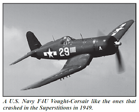
It was about 10:30 a.m. Wednesday, October 20, 1949 when three United States Navy F4U Vought-Corsairs pilots flew low over Safford, Arizona to avoid heavy clouds and rain. This was reported by a Safford resident as the planes roared over his home at a very low altitude. The three single place planes were being ferried from Quonset Point, Rhode Island to El Paso, Texas to Litchfield Park Naval Air Station for storage. A severe winter storm had moved into the state causing very low ceiling and lots of precipitation. Commander Marvin Hart believed he would have heard from the pilots if they had landed safely somewhere. The pilots of the Corsairs were Lt. (j.g.) George Albert Heckler, of Portsmouth, Va., Engs. James Truett Pilgreen of Shreveport, La., and Engs. John Earl Lawrence Jr., of Grosbeck, Tex.
Flight control at Litchfield and Williams A.F.B. believed the planes were down somewhere between Safford and Litchfield. Both the rugged Pinals and Superstition Mountains were the first places to be searched. On the morning of October 21, 1948, nearly fifty aircraft were launched to search for the three downed Navy Corsairs. Sixteen twoplace AT-6’s took off at dawn from Williams Air Force Base near Gilbert.
Charles S. Barnes, President of Phoenix Precipitation Control, a rain making company, spotted the wreckage of a Blue Corsair while searching the rugged Superstition Mountains east of Apache Junction and north of Superior. Barnes was flying a converted BT type aircraft.
Barnes reported the plane crashed in the snow and burned several Pinyon trees. He said he could identify the blue tail section of one of the planes. Barnes estimated the wreckage was due west of the Castle Dome mine and five miles north of the Superior-Miami Highway (Hwy. 60). The plane crashed near Government Hill about two miles northwest of the Toney Ranch in Haunted Canyon, and about two miles south of the Kennedy Ranch along the West Fork of Pinto Creek. The other two planes crashed on Granite Mountain just west of Campaign Creek near the Horrell Upper Ranch, known today as the Reavis Mountain School. The distance between the crash sites was seven and three-quarters miles.
The United States Air Force Fifth Rescue Squadron out of Williams Air Force Base sent a helicopter to the site. Lt. Herman T. Kennedy and Lt. Paul Obidowski piloted the helicopter into the dangerous and rugged terrain. Severe turbulence was common near the ground in the Superstition Wilderness Area. The helicopter was able to land on a 5,500 feet ridge (Government Hill). They were able to identify the body of one of the pilots of the Corsairs. Once the crash site was located, a rescue and recovery team of six Navy and two Air Force men would go to the site overland from a nearby ranch. By October 24, 1948 all three bodies of the pilots were recovered from the area.
During the war years (1941-1945) many training aircraft crashed in the Superstition Wilderness Area (Primitive Area). All of these aircraft have been recovered. Only one aircraft remained in the Superstition Wilderness Area as of 1961. This aircraft was an old PT-6 Waco Ryan that was located in Whiskey Springs Canyon.
Some time during early 1991, Richard Johnson became interested in the Navy Corsairs that crashed in the Superstition Mountains in 1949. He contacted me about their location. I was able to assist him with the plane near Government Hill.
I had visited that crash site in 1978 with Allen Blackman. I believe Royce Johnson, foreman for the old Miles Ranch, told Allen how to find the crash site. The area was rugged and brushy around Government Hill. Allen and I had ridden into the area on FS Trail 203 off of FS road 287A. At the top of the hill above Limestone Spring, we entered thick brush and broke our way through it to the old Corsair Navy F4U tail section. We photographed it and worked our way back to the trail and out.
Richard Johnson met a man named Craig McBurney who was interested in vintage aircraft. The three F4U Vought-Corsairs were packed out by Johnson and McBurney. The removal of the wreckage required thirty-five helicopter loads to remove it from the wilderness area and required six months to complete.
This was a major salvage project with the support of the Tonto National Forest Ranger District. Before this salvage project could be undertaken the United States Navy had to reopen the crash report and approve the salvage operation. The recovery operation of the three navy planes was accomplished under the direction of Richard Johnson.
Other pieces of the aircraft were packed out by a group of hikers. The United States Department of Agriculture wanted the wreckage totally removed from the Superstition Wilderness Area and therefore supported the operation. Without their cooperation the project could never have been accomplished.
